PUBLIC HEARING ITEM
ITEM NO. 7A: PID-1 AND M-1 to PRD-2; 8.83 ACRES; EAST OF RESEARCH PARK
DRIVE AND NORTH OF W. 15TH STREET (PGP)
Z-12-51-03: A request to rezone a tract of land approximately 8.83 acres from PID-1 (Planned Industrial Development) District and M-1 (Research Industrial) District to PRD-2 (Planned Residential Development) District. The property is generally located north of W. 15th Street and east of Research Park Drive. Initiated by the Planning Commission on December 17, 2003. W. David Kimbrell (contract purchaser) and Bobwhite Meadow LP, Mabet #1, and Hi-Tech Facility Investors, are property owners of record.
GENERAL INFORMATION
Current Zoning and Land Use: PID-1 (Planned Industrial Development) District, Partially developed with office buildings.
M-1 (Research Industrial) District, One vacant lot & unused portions of two lots developed with office buildings.
Surrounding Zoning and Land Use: M-1 (Research Industrial) District – to the north and west, Vacant.
M-1 (Research Industrial) District - to the east, Office Buildings.
PID (Planned Industrial Development) & M-1
(Research Industrial) District – to the south, Industrial Research/Office Buildings
Reason for Request: To convert an existing PID-1 (Planned Industrial Development) District and M-1 (Industrial) District to PRD-2 (Planned Residential Development) District to allow for 5 residential condominium loft buildings (total of 65 dwelling units).
At the December 17, 2003 meeting, the Planning Commission initiated a request for the applicant to submit a combined Preliminary Development Plan (Planned Industrial Development and Planned Residential Development) and tabled the two rezoning requests which were heard [PID-1 and M-1 to RO-1A (Z-10-36-03 and Z-10-37-03)]. This rezoning request (Z-12-51-03) covers the residential portion of the proposed Revised Preliminary Development Plan.
I. ZONING AND USES OF PROPERTY NEARBY
The subject property is located at the northwest corner of Wakarusa Drive and 15th Street and is surrounded to the north, east, south and west by M-1 (Research Industrial) uses, with vacant industrial lots to the north and west and developed office-research buildings to the east and south. The property is also part of, or adjacent to the Oread West Research Park Planned Industrial Development (PID-1).
Staff Finding - Z-12-51-03: PRD-2. The surrounding zonings and land uses are primarily M-1 Research Industrial and PID Planned Industrial Development with professional office buildings.
II. CHARACTER OF THE NEIGHBORHOOD
The proposed overall site that is requested to be rezoned to PRD-2 is 8.83 acres (M-1 to PRD-2 = 3.88 acres, PID-1 to PRD-2 = 4.95 acres). The majority of the site (4.95 acres) includes a large portion of the Oread West Office Park Planned Industrial Development (PID) which was originally approved in 1994.
When the Final Development Plan for Oread West Office Park was first approved in 1994/95, Wakarusa Drive was on the western edge of Lawrence. Over the past 9 years, the City of Lawrence has continued to grow to the west. The Oread West Office Park is now more than a mile within the city limits.
The approved Preliminary Development Plan for Oread West Office Park PID-1 (13.3 acres) includes 6 two-story and 7 one-story office/research industrial buildings totaling 125,890 square feet and a clock tower. To date, 5 of the 13 office/research buildings (41,055 square feet of office building, or approximately one-third of the PID) and the clock tower have been constructed. Eight of the approved 13 commercial building have not yet been developed.
The principal uses of the existing 5 buildings within the PID-1 are four professional office buildings and a bank. The proposed M-1 rezoning to PRD-2 request includes one vacant lot fronting on Research Park Drive and the rear approximately 135’ of two lots fronting on Wakarusa Drive. The proposed PID-1 rezoning to PRD-2 request includes portions of two lots, located at the northwest corner of Wakarusa Drive and W. 15th Street, and contains a portion of the Oread West Office Park Planned Industrial Development.
The rezoning requests are one element of part of a much larger area, within the middle of the larger Oread West Research Park development. Some lots within the M-1 (Research Industrial) area have yet to be developed. Of the business and buildings developed in the Oread West Research Park, nearly all are either research uses or professional and medical office buildings.
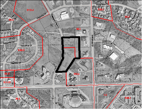
Aerial at 15th & Wakarusa Drive, February 2003, 1:6,000
Staff Finding - The subject property is located at the northwest corner of Wakarusa Drive and Bob Billings Parkway (W. 15th Street). The rezoning request includes an undeveloped 4.95 acres of the Oread West Office Park Planned Industrial Development, which is approximately one-third built-out.
The rezoning request also includes one vacant M-1 lot fronting on Research Park Drive and the rear approximately 135’ of two M-1 lots fronting on Wakarusa Drive. The proposed rezoning requests are in the center of the portion of Oread West Research Park located north of W. 15th Street.
III. SUITABILITY OF SUBJECT PROPERTY FOR THE USES TO WHICH IT HAS BEEN RESTRICTED
Appropriateness of continuing the Planned Industrial Development.
The Oread West Office Park was rezoned from M-1 (Research Industrial District) to PID-1 (Planned Industrial District) in November 1994 (Ordinance No. 6600). The City Commission approved the rezoning ordinance with the following use restrictions:
Restrictive uses per the approval of the rezoning (Z-4-14-94) Lots 1 & 2, Oread West #11: Uses in this PID-1 development shall be restricted by the rezoning ordinance, as well as shown on the Preliminary and Final Development Plans, to the following use groups: Use Group 1 – Agriculture - Animal Husbandry; Use Group 2 – Agriculture – Field Crops; Use Group 7 – Community Facilities and Utilities – Residential; Use Group 8 – Temporary Uses; Use Group 9 – Professional Offices, except veterinarian offices; Use Group 10 – Off-Street Parking; and, Use Group 18 – Research and Testing. In addition, the PID shall be limited to not more than 15 percent of the total land area being devoted to financial institutions, law offices, accounting offices, medical offices and architectural offices.
As noted in the 1994 rezoning report, the applicant had requested PID zoning because of constraints placed upon development in the conventional M-1 zoning district. Planned Unit Development zoning, such as this PID-1, allows a property owner to develop private streets within a development and to permit the division and sale of improvements as townhomes or condominiums. This provision in state law provides the ability to sell individual buildings to separate owners, but to retain the drives, off-street parking areas, and open spaces in common ownership.
Section 20-1013 of the Zoning Ordinance required “the establishment of an agency or entity to own, manage and maintain the common open space, open air recreation areas, recreation facilities, non-encroachable areas, private streets and any other area within the development that is to be retained for the exclusive use and benefit of the residents, lessees and owners.” The approved Final Development Plan, which is on file at the Register of Deeds Office, includes a note on the face of the plan which states that “Ownership of buildings will be by individual owner, whose lot will be the actual ground below the building. Ownership of the open space, drives and off-street parking areas is by the Oread West Office Park Owners Association, and is intended for the common uses and enjoyment of the Owner of lots within the Oread West Office Park. Maintenance of these areas will be by the Owners Association. These items are recorded in the ‘Oread Park Declaration of Covenants, Conditions, Restrictions and Dedication of Easements’.”
The townhouse/condominium type of real estate division does not involve review by the Planning Office and is an exemption from the Subdivision Regulations. Based on Zoning Regulations, the development is considered one project governed by the approved development plan without regard to the number of individual property owners involved.
Appropriateness of PRD-2
The rezoning request seeks to place a PRD-2 (Planned Residential District) zoning district within the middle of a M-1 (Research Industrial) District. Staff’s key planning issues with this request are:
· The request would constitute a new use, residential, within a research industrial area.
· The benefits of planned zoning and land use that exist within a Planned Unit Development provide better assurances for integration of uses into the established and planned ‘park’ setting than what the previously deferred conventional zoning can provide.
Staff Finding - In staff’s opinion, the property is suitable to the PID-1 Planned Industrial Development zoning and M-1 uses to which it has been restricted. Given the previous approved Final Development Plan of Oread West Office Park; the multiple ownerships involved in this project; the public improvements in the area; and the surrounding M-1 properties, the subject tracts are suitable for continuation as a Planned Unit Development. Rezoning of a portion of the property to PRD-2 and approval of a combined development plan for the PRD-2/PID-1 District provides assurances that the property will continue to develop in a unified manner.
IV. LENGTH OF TIME SUBJECT PROPERTY HAS REMAINED VACANT AS ZONED
Staff Finding -The PID-1 property has been zoned Planned Industrial District since 1994. The PID property is not vacant but is approximately one-third built-out with office buildings.
The M-1 property has been zoned M-1 since 1983 and contains one vacant lot and undeveloped portions of two adjacent lots.
V. EXTENT TO WHICH REMOVAL OF RESTRICTIONS WILL DETRIMENTALLY AFFECT NEARBY PROPERTY
Most of the surrounding property is zoned M-1 Research Industrial District.
The M-1 Research Industrial District is designed,
(a) to provide an industrial park type environment exclusively for, and conducive to, the development and protection of modern administrative facilities and research institutions, all of a non-objectionable type, and
(b) to protect nearby residential and commercial areas.
The rezoning request is for a PRD-2 Planned Residential Development District.
|
Zoning District Comparison |
M-1 Research Industrial |
PID-1 Planned Industrial Development |
PRD-2 Planned Residential District |
|
|
Lot Area |
1 acre within 35+ acre industrial park |
2+ acres |
2+ Acres, Maximum density =15 Dwelling Units/Net Residential Acre |
|
|
Lot Width |
200’ |
25% min. open space use |
15% minimum common open space use |
’20% minimum common open space use |
|
Lot Depth |
200’ |
|||
|
Front Yard Setback |
40’ abutting residential/ 15’ abutting nonresidential |
30’ |
15’ from public or private street, or 20’ from street if a driveway is provided |
|
|
Side Yard Setback |
Periphery Boundary 30’ |
Periphery Boundary 35’ |
||
|
Rear Yard Setback |
||||
|
Maximum Height |
3 stories/ 40 feet |
3 stories/35’ or per approved plan |
Per approved Plan |
|
|
Residential Density |
N/A |
N/A |
15 Dwelling Units/Net Residential Acre |
|
The accompanying Planned Unit Development (PDP-12-13-03) is proposing a residential density of 8.2 Dwelling Units per Net Residential Acre.
The proposed rezoning will impact the adjacent M-1 properties by requiring them to maintain a larger setback where abutting or across street from residential, than if they were adjacent to M-1 or PID.
The PRD-2 District allows a maximum of 15 residential dwelling units per residential acre. Permitted use groups within the PRD District includes: (1) residential dwelling units attached or detached, or a combination of both attached and detached units. (2) Nonresidential uses of a religious, cultural, educational and recreational character to the extent that they are designed and intended to serve primarily the residents of the Planned Residential Development. (3) Commercial uses to the extent they are designed and intended to serve primarily the residents and uses or activities of the Residential Planned Unit Development.
The M-1 Research Industrial District has the following permitted use groups: Group 1 – Agriculture – Animal Husbandry, Group 2 – Agriculture – Field Crops, Group 7 Community Facilities – Public Utilities, Group 8 – Temporary Uses, Group 10 – Off street parking, Group 18 – Research and testing.
The Oread West Office Park PID-1 has previously been restricted to the following permitted use groups by the approved development plan: Use Group 1 – Agriculture - Animal Husbandry; Use Group 2 – Agriculture – Field Crops; Use Group 7 – Community Facilities and Utilities – Residential; Use Group 8 – Temporary Uses; Use Group 9 – Professional Offices, except veterinarian offices; Use Group 10 – Off-Street Parking; and, Use Group 18 – Research and Testing. In addition, the PID shall be limited to not more than 15 percent of the total land area being devoted to financial institutions, law offices, accounting offices, medical offices and architectural offices.
Staff Finding - Removal of the existing restrictions and rezoning to PRD-2 would require a revised Preliminary and Final Development Plan and a replat of the property.
Rezoning the properties now zoned PID-1 will introduce residential uses into a developing office-research park and will require greater setbacks for undeveloped property west of Research Park Drive.
Rezoning properties now zoned M-1 will introduce residential uses into a developing research office park and will result in greater setbacks on vacant properties to the north and west.
VI. RELATIVE GAIN TO THE PUBLIC HEALTH, SAFETY AND WELFARE BY THE DESTRUCTION OF THE VALUE OF THE PETITIONER’S PROPERTY AS COMPARED TO THE HARDSHIP IMPOSED UPON THE INDIVIDUAL LANDOWNERS
The rezoning will take the property out of the available industrial research/office inventory. However, there currently exists an oversupply of developed office space in the local market. The potential benefits to the area would include additional investments in the area, renewed interest in the Oread West Research Park, and an increase in the activity levels. The mixed-use development concept has been validated by its increased use as a marketing and land use trend at the national level.
Staff Finding - The attributes of a mixed-use development will likely provide a renewed interest in the Oread West Research Park.
VII. CONFORMANCE WITH THE COMPREHENSIVE PLAN
An evaluation of the conformance of the rezoning request with the City’s Comprehensive Plan is based on the goals, policies and recommendations in Horizon 2020.
Page 63, - Medium-Density Residential Development. “Medium-density residential development, reflecting an overall density of 7 to 15 dwelling units per acre, is recommended at selected locations along major roadways, near high-intensity activity areas, and when adjacent to important natural amenities as cluster development.” Page 64 -“Most of the sites recommended for new medium-density residential development occupy transitional locations between single-family neighborhoods and office/commercial areas.”
Staff Finding - The proposed rezoning request is consistent with the Residential Goals and Policies of the City’s Comprehensive Plan, Horizon 2020. The request for PRD-2 zoning classification is generally consistent with the Land Use Goals and Policies of Horizon 2020.
STAFF REVIEW The applicant is requesting to rezone an existing partially developed Planned Industrial Development and adjacent M-1 Research Industrial property to a PRD-2 Planned Residential Development zoning district. The Oread West Office Park PID was approved in 1994/95 and allowed for specific uses as identified and laid out on the Preliminary and Final Development Plan which was approved by the Planning Commission. By converting and keeping the site as a Planned Unit Development rather than the applicant’s tabled request for conventional zoning, the following points can be achieved: · The Planning Commission will maintain their ability to be the local administrative authority reviewing and approving the proposed project.
· The Developer gains additional uses within the flexibility of a Planned Unit Development that encourages innovation and imaginative approaches in the design of the development. A conventional zoning would required a more constrained, rigid site planning process.
· The surrounding properties will maintain the specificity of a specific project through the Planned Unit Development process which assures a know quantity and quality of development. A conventional zoning district would allow a number of different uses that would be permitted by right.
· An approved development plan has a control mechanism which provides for developmental assurances for the surrounding property owners.
Based upon the staff report findings, the rezoning request presents a residential component to the overall Oread West Office Park.
PROFESSIONAL STAFF RECOMMENDATION
Planning Staff recommends approval of the rezoning request of 8.83 acres from PID-1 and M-1 to PRD-2 and forwarding the rezoning request to the City Commission with a recommendation for approval based on the findings of fact listed in the staff report and subject to the flowing conditions:
1. Approval of the Revised Preliminary Development Plan for Oread West Office Park; and
2. Maximum residential density of 10 Dwelling Units per Net Residential Acre.