NON-PUBLIC HEARING ITEM:
PUBLIC HEARING ON VARIANCE ONLY:
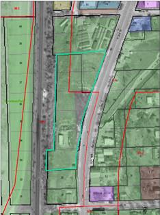
ITEM NO. 5: NORTH TOWN ADDITION; WEST OF NORTH 2ND STREET NORTH OF LYON STREET (SLD)
SUMMARY
PF-03-10-04: Final Plat for North Town Addition. This proposed one-lot industrial subdivision contains approximately 4.479 acres and is located west of North 2nd Street north of Lyon Street. Submitted by Landplan Engineering for North Town Development, LLC, Contract Purchaser, and P.D.O. Investors LLC, property owner of record.
GENERAL INFORMATION
Current Zoning and Land Use: M-3 (Intensive Industrial) District and C-4 (General Commercial) District; existing warehouse to be removed.
Surrounding Zoning and Land Use: M-3 (Intensive Industrial) District to the north, south and west; existing mobile home sales and open lot to the north and south, existing railroad right-of-way to the west.
C-4 (General Commercial) District to the east; and north; existing highway commercial uses.
Site Summary
Number of Lots: 1 proposed
Gross Area: 4.479 acres
Rights-of-way: No new proposed right-of-way dedications
Access Easements: Easements proposed at north and south ends of property
Development Proposal: SP-01-02-04 approved by the City Commission 3/30/04

REVIEW COMMENTS FROM OTHER DEPARTMENTS/AGENCIES:
Planning Department:
1. Floodplain development permit is required prior to development (Recommend applicant submit as soon as possible.)
2. Show lot 21 at top of drawing for reference. (Condition of approval)
1. Tie the point of beginning to section corners by distance and bearing. (Condition of approval)
2. Submit public improvement plans (extend sanitary sewer to property). (Applicant notified)
3. Floodplain impacts property development. Need to establish minimum building floor/opening elevations. Elevation certificate will be required. (Applicant notified)
4. 50’ of right-of-way is required from center line of street for Arterial Street. Note that majority or disproportionate ROW is provided on east side of street. (Plat denotes width of adjacent ROW)
5. Add note on face of plat to limit access points per the approved site plan. (Plat revised)
Stormwater Engineer: I have no comments on this plat. Refer to site plans.
Traffic Engineering: No Comments (Refer to Site Plan SP-01-02-04 for Traffic Impact Study documentation. CC approved Site plan 3/30/04)
Municipal Utilities: No Comments received
Neighborhood Resources: No Comments
Parks/Rec: Please check with legal services to make sure landscape easement measurements are correct. (Staff forwarded copy of plat for internal review)
Fire Department: No Comments
Police Department: No Comments
Westar: No Comments
Aquila: No Comments Received
Williams Natural Gas: No Comments Received
Southwestern Bell: No Comments
STAFF REVIEW
The subject property is located in North Lawrence on the west side of N. 2nd Street between N. 2nd Street and the railroad right-of-way, north of Lyon Street. The property is zoned for industrial uses. As noted, a site plan was previously approved by the City Commission. The proposed Final Plat will consolidate the remaining portions of lots and vacated rights-of-way to create a single lot for development.
The subject property includes both the M-3 (Intensive Industrial) and C-4 (General Commercial) District. Use Group 12 (Retail Stores) is not a permitted use in the M-3 (Intensive Industrial) District or any other industrial district. As part of the site plan consideration, the City Commission initiated a rezoning to change the portion of C-4 (General Commercial) District that encumbers the subject property to M-3 (Intensive Industrial) District. This rezoning will be brought to the Planning Commission as part of the May agenda.
Access and Rights-of-way
The subject property is adjacent to the west right-of-way line of North 2nd Street (Highway 24/40). This is a designated arterial street. Section 21-607.3 requires a minimum of 100’ of right-of-way exist from the center line of the street. The subject property would typically be required to provide additional right-of-way up to 50’ from the centerline. A disproportionate amount of right-of-way exists on the east side of the street.
The subject property is uniquely shaped as a result of various right-of-way dedications and vacations from other land actions. There is no clear record of right-of-way dedications along N. 2nd Street. There is no consistent right-of-way width along N. 2nd Street between North Street and Lyon Street.
SUMMARY
The subject property includes parcels that were originally platted as part of the North Lawrence Addition, but were modified by rights-of-way acquisition. The subject property has a long, narrow configuration and irregular boundaries.
The approved site plan includes three access points to the property. The two drives at the north and south ends of the property are provided with access easements to the abutting properties, limiting/reducing the number of direct driveway cuts to N. 2nd Street.
The subject property was previously filled and a Letter of Map Revision (LOMR) was approved for the building pad site, thus elevating the site above the regulatory 100-year base floodplain elevation reflected on the site plan. The eastern portion of the site was not included in this approval. A floodplain development permit will be required for development on this portion of the site. The applicant has indicated that no additional fill is proposed for the site.
The proposed Final Plat complies with the minimum zoning and subdivision regulations. The Final Plat reduces and consolidates access along N. 2nd Street and is a necessary step in the development process.
Minor corrections are needed on the face of the final plat that correct the mayor's endorsement and to remove the right of entry note for street tree planting since that element is only applicable to the RS and RMD districts. These corrections are reflected as conditions of approval
Recommendation: Staff recommends approval of the Final Plat of North Town Addition and forwarding it to the City Commission for acceptance of easements, subject to the following conditions:
- Execution of a Temporary Utility Agreement.
- Submission of public improvement plans to the Public Works Department prior to recording of the final plat.
- Provision of the following fees and recording documentation:
a. Copy of paid property tax receipt;
b. Recording fees made payable to the Douglas County Register of Deeds;
c. Provision of a master street tree plan.
4. Provision of a note on the revised Final Plat to state that there shall be no more than three (3) access points to the subject property and that cross access shall be provided at the north and south boundaries of the subject property.
5. Removal of the note related to right of entry for planting street trees.
6. Provision of a revised final plat to correct the mayor’s signature block.
7. Provision of a revised final plat to label lot 21 at top of drawing for reference.
8. Provision of a revised final plat to tie the point of beginning to section corners by distance and bearing.