PUBLIC HEARING ITEM:
ITEM NO. 5: C-4 TO M-3; 1.59 ACRES; NORTH 2ND STREET AND LYONS STREET (SLD)
SUMMARY
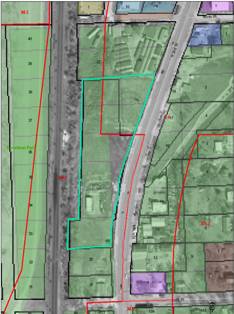
Z-05-17-04: A request to rezone a tract of land approximately 1.59 acres from C-4 (General Commercial) to M-3 (Intensive Industrial). The property is generally described as being located at the corner of North 2nd and Lyons Street. Initiated by the Planning Commission at their April 28 meeting. P.D.O. Investors, LLC, are the property owners of record.
GENERAL INFORMATION
Current Zoning and Land Use: C-4 (General Commercial) District; undeveloped. Portion of a larger tract known as North Town Addition.
Surrounding Zoning and Land Use: M-3 (Intensive Industrial) District to the north, south and west; existing mobile home sales and open lot to the north and south, existing railroad right-of-way to the west.
C-4 (General Commercial) District to the east; and north; existing highway commercial uses.
Reason for Request: Initiated by the Planning Commission to remove the split zoning boundary across the subject property known as North Town Addition.
Site Summary
Total Gross Area: 4.479 acres
Development Proposal: SP-01-02-04 approved by the City Commission 3/30/04.
FP-03-10-04 North Town Addition Approved by the City Commission on 3/30/04.
I. ZONING AND USES OF PROPERTY NEARBY
Staff Finding – The surrounding area includes a mix of zoning and land uses along N. 2nd and N. 3rd Streets. The property known as North Town Addition is encumbered by both commercial and industrial zoning. The approved plat and site plan are designed and intended for industrial development.
II. CHARACTER OF THE AREA
Staff Finding – North 2nd Street is an existing gateway to the community as well as a developed industrial corridor. Surrounding development is best described as intensive commercial/industrial in nature.
III. SUITABILITY OF SUBJECT PROPERTY FOR THE USES TO WHICH IT HAS BEEN RESTRICTED
Staff Finding – The split zoning of the whole property often complicates administration of the zoning ordinance by allowing commercial uses on a portion of the property (with commensurate parking) and limits commercial/retail uses on other parts. The property has recently been site planned and re-platted to accommodate redevelopment of the property. The currently commercial zoning is not suitable given the recent land use approvals to accommodate redevelopment of the property.
IV. LENGTH OF TIME SUBJECT PROPERTY HAS REMAINED VACANT AS ZONED
Staff Finding – The subject property is zoned for commercial uses. The original 1966 map is difficult to interpret, but it appears that the commercial zoning has been in place for all or a portion of the property since 1966. Approval of the request will clearly delineate the boundary to the centerline of the existing right-of-way and follow the platted boundary to eliminate a question of the location between the commercial and industrial districts in this area.
V. EXTENT TO WHICH REMOVAL OF RESTRICTIONS WILL DETRIMENTALLY AFFECT NEARBY PROPERTY
Staff Finding – The proposed request is somewhat sterile in nature in that it accommodates administration of the zoning regulations and will clearly articulate the boundary between adjacent districts to follow common or recognized boundaries such as right-of-way and platted lot lines. The approval reduces the area of the C-4 (General Commercial) District along N. 2nd Street in this area. The property could not have efficiently been developed for commercial uses in the current configuration. The proposed change will not detrimentally affect adjacent properties.
VI. RELATIVE GAIN TO THE PUBLIC HEALTH, SAFETY AND WELFARE BY THE DESTRUCTION OF THE VALUE OF THE PETITIONER’S PROPERTY AS COMPARED TO THE HARDSHIP IMPOSED UPON THE INDIVIDUAL LANDOWNERS
Staff Finding - Evaluation of the relative gain weighs the benefits to the community-at-large vs. the benefit of the owners of the subject property. Benefits are measured based on anticipated impacts of the rezoning request on the public's health, safety and welfare. The Planning Commission initiated the proposed change based on the analysis and staff recommendation of the Final Plat. Approval of the change will facilitate a cleaner transition upon adoption of the new zoning codes and the map transfer that will correspond with the adoption of the text.
VII. CONFORMANCE WITH THE COMPREHENSIVE PLAN
The subject property is part of North Lawrence and is also located along the N. 2nd Street corridor which includes a range of commercial and industrial uses. Horizon 2020 addresses this area as follows:
· Union Pacific Railroad Corridor
This corridor serves North Lawrence and has historically been the site of industrial uses. Industrial development patterns along the corridor are somewhat fragmented with interspersed residential and commercial land uses. Many industrially zoned sites have been developed with residential structures or represent vacant lots originally divided for residential purposes. This corridor may also offer opportunities for business owners to establish smaller industrial operations within the community.
New development and redevelopment in the area should be encouraged to establish standard-size development parcels and upgrade and improve the appearance and image of the area. In general, Locust Street, Maple Street and Lincoln Street west of 7th Street should continue to serve as industrial collector streets in the neighborhood and efforts should be made to discourage non-residential traffic in other parts of the neighborhood.
· N. 2nd Street and N. 3rd Street
The Comprehensive Plan recommends that N. 2nd Street and N. 3rd Street provide an enhanced role in the community as a commercial corridor. N. 2nd Street and N. 3rd Street act as an important entryway/gateway to the City of Lawrence. This corridor is considered to be an Existing Strip Commercial area. The Comprehensive Plan identifies the intersection of the N. 3rd Street and Interstate 70 to be possible location for an Auto-Related Commercial Center.
Marginal, obsolete and underutilized sites and incompatible uses along this corridor should be redeveloped or reconstructed. For example, existing heavy industrial uses along the northern portion of the corridor should be relocated within the planning area and the sites redeveloped with compatible commercial, service or retail uses. New development and redevelopment shall include improved parking, signage and landscaping improvements that enhance the overall aesthetic and environmental conditions along the corridor. The City should encourage and work with land owners to undertake property improvement within the area. The City should consider special financing mechanisms, such as benefit districts or tax increment financing to assist in private and public improvement projects for the area.
Historically, the North Lawrence area including the N. 2nd and N. 3rd Street corridor has had repeated floodwater and stormwater problems. The Comprehensive Plan recommends that , as soon as possible and before any additional new development occurs along the N. 2nd Street and N. 3rd Street corridor, a comprehensive drainage study be completed. The study shall be a joint project between the City and private property owners. The drainage study shall provide a plan for addressing existing flooding and stormwater problems, as well as, devising a plan for dealing with additional runoff from future development in the area.
North Lawrence Neighborhood Plan was also reviewed with respect to the proposed change. The plan stated “the predominate land uses in North Lawrence are residential and industrial.” The “objective” of the Plan was to “delineate separate areas for land uses” to reduce the potential for conflict (See attached map). The plan recommended industrial uses for large areas along North 2nd Street and in areas adjacent to the railroad tracks through the central part of the neighborhood.
Staff Finding - The proposed request will amend the district boundary to follow a more regular pattern in the neighborhood and facilitate the administration of the code with respect to commercial/industrial uses within the specific property. The approved Site Plan and Final Plat are initial steps for a redevelopment project known as North Town Addition. The subject property could have been developed without this change. Approval of the request clearly establishes the industrial land use district along the west side of N. 2nd Street in a manner that is definable based on platted lot lines.
The overall redevelopment project is an example of infill development within an existing industrial corridor as recommended in Chapter 7 of Horizon 2020.
N. 2nd Street will function as the dividing line between the industrial and commercial districts in this area. More specific land use recommendations related to site orientation, building relationships, screening, landscaping and lighting were previously addressed as part of the site plan review.
STAFF REVIEW
As noted in the summary the subject property was included in a site plan and Final Plat known as North Town Addition. The publication of the rezoning ordinance will be held until the Final Plat is recorded with the Register of Deeds Office to assure that the platted boundaries and the zoning boundaries align.
There are no conditions associated with the recommendation. The property has recently been platted. The zoning boundary will be compared to the plat boundary to assure they align.
PROFESSIONAL STAFF RECOMMENDATION
Staff recommends approval of the proposed 1.59 acres from C-4 (General Commercial) District to M-3 (Intensive Industrial) District and forwarding it to the City Commission with a recommendation for approval based upon the findings of fact found in the body of the staff report.