|
PLANNING COMMISSION REPORT SUMMARY PUBLIC HEARING ITEM |
|
ITEM NO. 3: CONSIDERATION OF THE NEW DEVELOPMENT CODE, NOVEMBER 17, 2004, EDITION THAT REPLACES THE EXISTING ZONING ORDINANCE NO. 3500 AND ALL AMENDMENTS SINCE ADOPTION IN 1966 (LMF)
TA-10-05-04: Pursuant to the provisions of K.S.A. Chapter 12, Article 7, consider the adoption of “Development Code, November 17, 2004, Edition,” enacting a new Chapter 20 of the Code of the City of Lawrence, Kansas, establishing comprehensive zoning regulations and other land use regulations. The “Development Code, November 17, 2004 Edition” is a general and complete revision of the City’s existing zoning regulations, Ordinance No. 3500 and all amendments thereto, and affects all property within the corporate limits of the City of Lawrence, Kansas. The “Development Code, November 17, 2004 Edition” is incorporated by reference as if fully set forth in this notice. Copies of the “Development Code, November 17, 2004 Edition” are available for review at the Office of the Lawrence-Douglas County Planning Department, City Hall, 6 E. 6th Street, Lawrence, Kansas. The “Development Code, November 17, 2004 Edition” is also available on the Planning Department’s website at: www.lawrenceplanning.org. This item was referred back to the Planning Commission by the City Commission at their meeting on July 20, 2004. |
|
There are two staff recommendations and two actions that need to be taken on this item.
1. RECOMMENDATION ON CITY/KU AGREEMENT: Staff recommends the Planning Commission forward a recommendation to the City Commission for approval of the “Cooperative Agreement between the City of Lawrence and the University of Kansas.” Staff also recommends that the City and KU discuss the process one year from adoption, or after the next construction project within 150’ (inside or outside) the Primary Campus boundary, whichever comes first, to clarify and/or improve on the process set forth in this Cooperative Agreement 2. RECOMMENDATION ON DEVELOPMENT CODE: Staff recommends forwarding a recommendation for approval of the “Development Code, November 17, 2004 Edition,” to the City Commission with the revisions itemized in the following conditions: 1. Revisions noted in the Errors, Omissions and Clarifications table and revisions to graphic illustrations be incorporated into the text of the Development Code; 2. The addition of a U(UK) subcategory of the University District to apply to that portion of the University of Kansas campuses covered by the Cooperation Agreement between the City of Lawrence and the University of Kansas; and, 3. Revisions to the densities of the RSO district to 3500 square feet/dwelling units and the RMO district to 22 dwelling units/acre to reflect the intent and purpose of the two levels of residential-office zoning districts.
|
|
Reason for Request: |
The Zoning Code is one of three major tools provided by State Statutes to implement a Comprehensive Land Use Plan. A diagnostic review of the Zoning Code was initiated shortly after adoption of HORIZON 2020, the City/County Comprehensive Land Use Plan. The Development Code is based on this diagnostic review and incorporates both the Zoning and Subdivision Regulations for the City of Lawrence. Adoption of this Development Code, a regulatory tool to help implement HORIZON 2020, is consistent with State Statutes. |
|
KEY POINTS FOR ADOPTION OF THE DEVELOPMENT CODE
· The Development Code provides residential zoning districts and densities that are consistent with HORIZON 2020’s categorization of very low, low, medium, and high density residential development. · Articles in the Development Code are written to be inclusive of related development policies such as stormwater management, access management, and retail market analysis. · The development process created in the Development Code provides increased opportunities for public involvement and awareness during all phases of the development process. · Land uses are grouped into larger categories of uses to be more inclusive of similar uses and to permit similar uses in the same land use categories. · Home Occupations have been expanded to permit limited types of home occupations to involve a non-resident employee. · Development standards such as outdoor lighting, landscaping, off-street parking and required transitions between unlike land uses have been developed for all conventional zoning districts, in addition to Planned Developments. · Smaller lot residential zoning districts, RS5 and RS3, have been created to address infill development and redevelopment on existing lots platted within the older areas of town where standard lot sizes are less than 7000 square feet. · Special purpose base districts have been created for uses that are unique based on their association with a public institution, open space, or zoning situation (such as land newly annexed without benefit of an area plan). · Administrative and legislative processes have been more clearly defined to improve the flow of development review while maintaining access and transparency to the process.
|
|
RELEVANT GOLDEN FACTOR:
|
|
ASSOCIATED ITEMS ON THIS AGENDA
|
|
PUBLIC COMMENT RECEIVED PRIOR TO PRINTING
|
Staff Report
There are four major components to this staff report. They are:
1. A history of the public process that has occurred in the adoption of the Development Code;
2. Review and consideration of a cooperative agreement between the City of Lawrence and the University of Kansas, forwarding to the Planning Commission for consideration in their deliberations on the Development Code;
3. Substantive changes recommended to the draft Development Code identified since the Planning Commission forwarded their recommendations on February 11, 2004 on the Development Code to the City Commission, and
4. Review and consideration of the Errors and Omissions table developed by staff to highlight errors, omissions and clarifications made to the draft Development Code to be consistent with the Planning Commission’s actions on February 11, 2004.
v TIMELINE OF PLANNING COMMISSION PUBLIC MEETINGS, PUBLIC HEARINGS AND RECOMMENDATION ON THE DEVELOPMENT CODE
June 2003 the Planning Commission received copies of the draft Development Code and established a timeline for public meetings and work on the Development Code.
Six public meetings were held throughout the months of July, August and September to receive comments and questions about the proposed regulations.
At the August mid-month meeting the Commission received a summary from staff of the major revisions, additions or omissions proposed in the draft Code.
In September the City Commission received a briefing from staff on the major issues identified by the public, Planning Commission and Planning Staff with the draft Code.
In October and November staff worked with Planning Commissioner Schachter to quantify the types of public comments received [editorial, minor or significant] and made revisions to the draft Code based on a priority given to these issues by the Planning Commission in September.
In December the Planning Commission’s agenda included consideration of the draft Code. Due to the excessive length of that meeting agenda, consideration of the Code was deferred to the January 2004 meeting.
The draft Code, as revised based on Commission and public comment, was placed on the January agenda. The January meeting was recessed twice and the Commission finally took up consideration of the revised draft Code on February 11th, along with a list of unresolved issues that required independent decisions by the Commission prior to approval of a version of the Development Code and the forwarding of a recommendation to the City Commission for adoption.
The City Commission and Planning Commission met in joint session on February 27th to receive the Planning Commission’s recommendation.
Staff worked with the consultant to resolve formatting and technical issues with revisions to the draft Code through April 2004.
Staff developed an Implementation strategy and developed applications, how-to forms, pamphlets, and other tools for public outreach when the new Code is adopted.
Zoning map implementation and necessary revisions were identified by staff and presented to the Planning Commission in July 2004.
A City/KU task force appointed by the Mayor and Chancellor worked throughout 2004 on the development of a Cooperative Agreement to be used in place of the zoning ordinance in regulating development and construction projects on the University campus that would occur within peripheral buffer areas. A recommendation from the task force was taken to the City Commission in July 2004.
Staff identified, through the creation of a review and implementation process, errors, omission and clarifications needed to the draft document. A report was taken from staff to the City Commission in July 2004.
The Planning Commission initiated for the November 2004 meeting the individual map designations necessary for properties being rezoned to the special purpose base districts of GPI, OS, U, H, UR, and PUDs at their August 2004 meeting. The Commission also initiated map designation revisions for consideration at the December 2004 meeting for the 13 CP zoned properties and for portions of 10 older neighborhoods [Pinckney, Old West Lawrence, Oread, North Lawrence, East Lawrence, Brook Creek, Barker, Centennial, Breezedale and University Place] to RS5 to conform to the smaller platted and developed lot sizes in these neighborhoods.
v COOPERATION AGREEMENT BETWEEN CITY OF LAWRENCE AND UNIVERSITY OF KANSAS
History of Task Force:
In spring 2004, Mayor Dunfield and Chancellor Hemingway, created a joint task force of City, University and Planning Commission representatives. The task force discussed the U (University) District, land use regulations, the mission of the University of Kansas, and the interests of the City in providing a better process in keeping neighborhoods, adjacent to the University campus, aware and involved in a public process for development on the fringe areas of campus. The result of multiple meetings and draft agreement proposals is the Cooperation Agreement, jointly drafted by the City and University staff that was presented to the City Commission on July 6, 2004. The City Commission forwarded the proposed Agreement to the Planning Commission for comments and recommendation.
Purpose of Agreement:
The intent of this agreement is to provide a mutually acceptable process for achieving some degree of land use control over future development on the university’s primary campus, specifically within a 150’ buffer area measured inward from the periphery of the Primary Campus as defined by map in Exhibit A of the Agreement.
Key Points:
§ This is the first written agreement between the City and the University of Kansas to set forth a process for development review and public input.
§ This agreement is entered into voluntarily by both the City and the University of Kansas.
§ The public review and development process outlined in the Agreement will apply to a buffer area from the boundaries of the Primary Campus for a distance of 150’ inside the boundaries.
§ Expansions of the Primary Campus, after the date of adoption of the Agreement, will be subject to the City’s zoning regulations and the standards in the U district.
§ Zoning of the Primary Campus to a separate map designation from the U (University) District designation, such as U (UK) University of Kansas District, is consistent with the intent of both parties that drafted the Cooperative Agreement. The U (UK) District will be solely governed by the terms of the Cooperative Agreement.
§ The Agreement establishes a notification process to the city and neighborhood residents from the University for development projects that lie within the 150’ buffer area of the Primary Campus.
§ The Agreement also establishes a notification process to the University from the City for development projects, rezonings, liquor license applications and environmental citations & other Code violations for an area 150’ outside of the Primary Campus boundaries.
§ The Agreement outlines the process for an impact analysis by the University for construction within the 150’ buffer area within the Primary Campus.
§ The Agreement requires an annual notice from the University of Kansas to the City Manager of the University’s five year Capital Improvements Plan, as approved by the Board of Regents.
§ Either party to the Agreement may terminate the Agreement upon 180-days written notice.
Summary:
The Cooperative Agreement is a document that was developed out of compromise and mutual trust between University and City staff. Areas of land use regulation that are included in the agreement are not as far reaching as the standards set forth in the U (University) zoning district. The University has not committed to be subject to public hearing and public notice requirements established for zoning and development within the City of Lawrence. However, there is a process outlined in the Agreement that involves adjacent property owners/neighborhood representatives that is based on a process the University engaged in midway through the Scholarship Hall development process along Ohio Street.
The one unknown about the Agreement is how well it will work in actual practice, when the next major development project is proposed within 150’ of the peripheral boundary of the Primary Campus. In the spirit of implementation being a method of improving on a process, staff would recommend the Agreement be reviewed jointly one year after adoption by City and University staff, or at the conclusion of the next development project within the buffer area or 150’ outside beyond the Primary Campus. The intent of this review would be to improve upon or clarify points or procedures that would lead to a smoother cooperative process.
v RECOMMENDATION ON CITY/KU AGREEMENT: Staff recommends the Planning Commission forward a recommendation to the City Commission for approval of the “Cooperative Agreement between the City of Lawrence and the University of Kansas”. Staff also recommends that the City and KU discuss one year from adoption, or after the next construction project within 150’ of the Primary Campus boundary, whichever comes first, to clarify and/or improve on the process set forth in this Cooperative Agreement.
v ERRORS AND OMISSIONS TABLE FOR DEVELOPMENT CODE, NOVEMBER 17, 2004, EDITION.
The Development Code was presented by staff to the City Commission on February 27th, 2004 at a joint meeting between the City Commission and the Planning Commission. Since that time, staff has been working on the implementation strategies and steps for the new regulations. As part of this process, public information brochures, pamphlets, maps and other handouts have been drafted to assist in the transition period between old zoning regulations and the new Development Code.
Using the February 11th draft of the Development Code to develop these implementation measures provided staff with the opportunity for hands on use of the Code and through a review process, a list was developed of errors, omissions and sections that needed clarification. Where a revision to text was minimal, the change was made in the November 17th edition and noted in the E&O Table. When a revision to text was of a more substantial type of change, or when it included the development of new section or revisions to multiple sections, the revisions were not made to the November 17th edition of the Development Code.
Under Tab 3 in the notebook is the Table of Errors and Omissions. This Table of Errors and Omissions has been posted on the Planning Department website along with the “Development Code, November 17, 2004 Edition” since the legal notice was published for the November 17, Planning Commission meeting on October 27th. The posting has been kept updated and current as additional minor revisions or errors have been discovered.
Revisions to Graphic Illustrations in the draft Development Code.
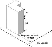
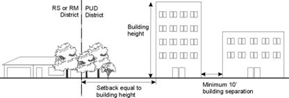
The Planning Commission’s February 11, 2004, recommendation to the City Commission on the draft Development Code included the addition of graphic illustrations. The consultants developed and added the illustrations to the Code. In staff’s review of these illustrations, several require modifications to accurately depict code language or the intent of the Planning Commission. One particular illustration in Article 6, which was intended to represent the relationship of buildings in non-RS zonings to RS zoned property establishes the building setback as a minimum number that is then increased, foot for foot, as the height of the building exceeds 35’. This is different from the standard established in Planned Districts where the setback from the peripheral boundary is the horizontal distance that is equivalent to the height of the building.
Clarification on the intent of the Planning Commission is needed. Was the standard to be the same for base zoning districts adjacent to RS zonings as Planned Districts adjacent to RS zonings or was a minimum setback intended for base zonings that abut RS zoned properties with required additional setback for every foot of height a building is above the height set in section 20-601 of the Density and Dimensional Standards section? [The graphic illustrations follow this page.]
Staff Recommendation on the Table of Errors and Omissions and on Revisions to Graphic Illustrations in the Development Code: Approve the revisions listed in the Table of Errors and Omissions and approve the revisions to graphic illustrations noted by staff in this report, incorporating these revisions into the Development Code, November 17, 2004 Edition, by reference.
02(h)(2)(ii)
20-701(g)(4)(ii)
Delete This Drawing From Section 602 And Replace
With Drawing For 20-701. Revise Text On 701 Drawing To Pd Not Pud And
When Placed In 602 Replace Pud With ‘Not Rs Zoning’ And Rs Or Rm With Rs
Zoning Or Detached Dwellings.
20-501(c)(2)(v)
ATTACHED DWELLINGS IN RS10, RS7 AND RS5
_______________________________________________________
20-501(c)(3)(vii)
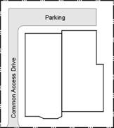
NOTE: COMMON ACCESS DRIVE TO STREET Or ALLEY ACCESS FOR ATTACHED Dwellings In RS5.
v SUBSTANTIVE ISSUES RAISED FOR CONSIDERATION, CLARIFICATION AND POSSIBLE REVISION TO THE DEVELOPMENT CODE
Since the Planning Commission recommended approval of the draft Development Code on February 11, 2004, staff has been working on a program for implementation of the Development Code, including staff training on the new development process and procedures. The Code’s formatting and illustrations have been revised to reflect the amendments recommended by the Planning Commission in February. Additional revisions are necessary to reflect staff’s requests for revised illustrations to better illustrate specific sections in the new regulations. During staff’s training and regulatory review process, errors, omissions and clarifications were identified in the Development Code. To make this a more comprehensive and understandable document, a Table of Errors & Omissions was developed for Planning Commission review. Twelve of the clarifications identified by staff impact the intended Code language and therefore have been judged to be substantial, warranting a “second look” by the Planning Commission. A list of 11 of these was submitted to the City Commission on July 20th for information and referral back to the Planning Commission for consideration. A 12th item was identified in staff’s work on the process & procedural steps for registration of non-conforming uses. Through the process of creating a list of potential properties that would need to register as non-conforming uses, an error was found in the maximum residential density permitted in the RMO district. The following portion of this section of the staff report individually highlights the substantial changes identified by staff. A recommendation follows the presentation of each of the 12 substantive issues. A list of these issues is in the box below:
|
1. Sec. 20-218. Revisions to the U (University) District to accommodate a separate district for the new map designation of U (UK) for the Primary Campus of the University of Kansas. 2. Sec. 20-501(j) Revision to the room number thresholds established for accessory uses to hotels. 3. Sec. 20-501(v)(1) Revisions to the congregation seating thresholds for Religious Assembly. This change also impacts the definitions for the two types of Religious Assembly in Sec. 20-1702 (ww) 4. Sec. 20-501(aa) Revision to the design standards for retail establishments. 5. Sec. 20-501(dd) Revision to the Telecommunication Facilities review fee. 6. Sec. 20-502(9)(ii) Revision to the registration process for Type B Home Occupations. 7. Sec. 20-1305(k) and 20-1301(a) Revision to the Site Plan appeals process. 8. Sec. 20-1306(c) Revision to the Special Use application to require a site plan. 9. Sec. 20-1307(a)(1) and (b) Revisions to Institutional Master Plan & Buffer Area requirements. 10. Sec. 20-1506 Revisions to the Registration process for Nonconformities. 11. Sec. 20-1108 (new section) Addition of the requirement for a Market Impact Analysis. 12. Sec. 20-205 and 20-601(a) Revisions to the residential densities permitted in RSO & RMO Districts. |
_____________________________________________________________________________
1. Sec. 20-218. Revisions to the U (University) District to accommodate a separate district for the new map designation of U(UK) for the Primary Campus of the University of Kansas.
Consistent with the approval and adoption of the Cooperative Agreement between the City and the University of Kansas, a special U(UK) (University of Kansas) District, needs to be added to Sec.20-218(a) to represent on the zoning map the primary campus of the University of Kansas. This text revision is shown on the following page in italics.
Section 218 [Article 2 Base Districts]:
20-218 U, University Districts
(1) Purpose
(i) The U, University Zoning District is a special purpose base District intended to provide a mechanism for establishing a zoning and land-use plan for an Institutional Campus type educational use.
(ii) The U (UK), University of Kansas zoning district, is a special purpose base District intended to apply to the Primary Campus defined in the Cooperation Agreement between the City and the University of Kansas. The purpose of this District is to provide a map designation to this significant area of land within the city. It is not intended to implement the regulations in this chapter.
Recommendation #1: Staff recommends revising Section 20-218 to include a specific map designation for the University of Kansas Primary Campus area that is depicted in Exhibit A of the Cooperative Agreement between the City of Lawrence and the University of Kansas.
2. Sec. 20-501(j) Revision to the room number thresholds established for accessory uses to hotels
Accessory uses such as bars, restaurants and nightclubs are permitted for hotels & motels based on a sliding scale that uses number of rooms as the measuring tool. In reviewing the implementation of this section on existing motels and hotels it was discovered that the number of minimum rooms set for each type of accessory use is too high for the Lawrence market. Following up on staff’s informal survey of hotel/motel accommodations, a discussion of potential future motel/hotel development(s) occurred with Judy Billings, the Director of the Convention and Visitors Bureau. Based on this information, staff would recommend the minimum number of rooms necessary to permit each type of accessory use be scaled back to represent the local market. This change was determined to be substantive because: 1) without this change every hotel/motel with an existing accessory use in Lawrence would become a non-conforming use; 2) the hotel/motel industry is unlikely, according to the Visitors Bureau to develop a larger establishment in Lawrence without conference facilities; 3) the intent of the Code was to provide development standards for each type of accessory use to a hotel/motel, not to create non-conformance of every establishment in the industry in Lawrence.
The
text revision proposed is shown in italics and the text being replaced
is shown with a strike through it.
Section 501 [Article 5 Use Regulations]:
(i) Eating and Drinking Establishments Involving Alcoholic Beverages
__________________________________________________________________________
The restrictions in (1) and (2) shall apply to a licensed Premises use. The fast order food establishments in (3) and (4) are not permitted to be a licensed Premises:
(1) Accessory Uses to Hotels
A
hotel with 50 100 or more rooms may have a restaurant as an Accessory
Use; a restaurant may be permitted as a second Principal Use on the same
property as a smaller hotel with less than 50 rooms, subject to all of the
other conditions applicable to the use and the district in which it is located,
including separate Parking requirements.
A
hotel with 100 200 or more rooms may have a bar as an Accessory
Use, subject to all of the other conditions applicable to the use and the
district in which it is located, including separate Parking requirements.
A
hotel with 150 300 or more rooms may have a nightclub or other live
entertainment as an Accessory Use.
Recommendation #2: Staff recommends revising section 20-501(i) in the recommended text revisions above with 50, 100 and 150 or more rooms as the thresholds for the accessory uses of restaurant, bar, and nightclub, respectively.
3. Sec. 20-501(v)(1) Revisions to the congregation seating thresholds for Religious Assembly. This change impacts the definitions for both types of Religious Assembly in Sec. 20-1702 (ww).
Trial implementation and additional staff research of the two types of Religious Assembly, Neighborhood and Community, have identified the need to reconsider the seating threshold that was revised down from the 300 seats in the consultant’s version of the Code to 250 seats. In a survey of site plan records dating back to 1967 for churches, over 50% of the churches that currently serve a neighborhood have over 250 seats in their worship area. Raising the seating capacity in the principal worship area to 500 would permit 84% of the churches site planned in the last 25 years to be classified as neighborhood religious institutions, based on the definitions in the new Development Code. To obtain a more comprehensive record of the seating capacity of principal worship areas of existing religious institutions, planning staff has discussed with the fire inspector collecting this data as they do annual inspections over the next calendar year.
The
text revision proposed is shown in italics and the text being replaced
is shown with a strike through it.
Section 20-501 [Article 5 Use Regulations]:
(v) Religious Assembly
(1) Neighborhood Religious Institutions
(i) Size
(1)
A Neighborhood
Religious Institution in an R District shall be limited to a seating capacity
of no more than 500 250 persons in the sanctuary or other
principal place of worship or assembly; and,
(2) The seating capacity of the sanctuary or other principal worship or assembly space shall not exceed a number equal to the Lot Area (expressed in square feet) divided by 100.
AND
Section 20-1702 [Article 17 Terminology]:
(ww) Religious Assembly
Religious services involving public assembly such as customarily occurs in synagogues, temples, mosques and churches.
(1) Neighborhood Religious Institution
A Neighborhood Religious Institution is an institution of
which the primary use is holy day worship services, with incidental educational
programs and some weekday services. It is a small-scale use, seating 500
250 or
fewer people. Accessory Uses are limited. The small scale of the institution
and the limitation on extensive non-worship uses make the institutional use
generally compatible with residential neighborhoods.
Recommendation #3: Staff recommends revising section 20-501(v)(1) in the recommended text revisions above to establish neighborhood religious institutions.
4. Sec. 20-501(aa) Revision to the design standards for retail establishments.
The CDSC (Commercial Design Standards Committee) of the Planning Commission has been working since February on the development of specific design standards and guidelines for commercial/retail development. The CDSC presented their preliminary recommendations to the Planning Commission in October. The design standards in this section of the Development Code are not representative of the standards being represented by the CDSC. To avoid confusing the public by adopting standards that are not representative of the committee’s work and therefore the standards that will be presented for public discussion within the next two months, deleting the standards in the February 11, 2004 version of the draft Development Code would be reasonable. The first paragraph of this section can be modified to anticipate the City’s future adoption of design standards and guidelines for commercial/retail development. This is also consistent with other sections in the Development Code that refer to separately adopted city policies related to development.
The
text revision proposed is shown in italics and the text being replaced
is shown with a strike through it.
Section 20-501 [Article 5 Use Regulations]:
(aa) Retail Establishments
(1) Purpose
These standards are intended to ensure that development of retail establishments, including large, medium, and specialty sales establishments, is compatible with its surrounding area and contributes to the unique community character of Lawrence. All development and re-development of retail establishments shall exhibit uniform design characteristics based on adopted commercial design development standards.
[All subsequent subsections of (1) that detailed specific design standards would be deleted.]
(2) Retail Market Study Market
Impact Analysis
A
Commercial Center proposed for more than 150,000 175,000 gross
square feet of commercial space is required to have a market impact analysis
study submitted
at the time of application for rezoning in accordance with Chapter 6 of the
Comprehensive Land Use Plan. Section
20-1108.
Recommendation #4: Staff recommends revising section 20-501(aa) in the recommended text revisions above.
5. Sec. 20-501(dd)(6) Revision to the telecommunication facilities review fee.
This is the only place in the Development Code where a specific review fee is established, in all other instances, the Code refers the reader to a fee schedule set by separate policy ordinance by the City Commission. Discussion with telecommunication industry providers and other planning departments has identified there is no relationship between the $20,000 fee set and the actual cost of studies done by/for telecommunication providers by consultants in that serve the industry. Staff has also asked telecommunication consultants to review this section of the Development Code, similar to the professional engineering and architectural consultants that created comparative implementation scenarios using both the existing and the draft Code. Suggestions received in response to this review opportunity would improve the regulations in the Development Code.
The
text revision proposed is shown in italics and the text being replaced
is shown with a strike through it.
Section 20-501 [Article 5 Use Regulations]:
(dd) Telecommunications Facilities
In lieu of other Dimensional and Density standards, Telecommunications Facilities shall be subject to the following standards.
(1) Applicability of Regulations
In Districts where Telecommunications Towers are allowed as a Special use (S), if there is already a lawful Telecommunications Tower on the site, a Telecommunication Antenna may be allowed as an Accessory Use if installed on that Telecommunication Tower. In Districts where a Telecommunications Tower is allowed as an Accessory Use (A*), a Telecommunications Antenna is allowed as an Accessory Use affixed to an existing Telecommunication Tower, Building or other Structure, subject to the criteria set forth in this section and applicable dimensional requirements of this Development Code.
(2) Standards Applicable to Construction of All Telecommunications Facilities
The following standards shall apply to any Telecommunications Tower or Telecommunications Antenna:
(i) No commercial advertising shall be allowed on a Telecommunications Facility, unless such Telecommunications Antenna is actually located on an existing, approved sign. Telecommunications Towers may have safety or warning signs in appropriate places;
(ii) No signals, lights or illumination shall be permitted on a Telecommunications Facility, unless required by the FAA. Should lighting be required by State or Federal law, the lighting shall be placed on the Telecommunications Tower and designed in such a way as to minimize to the fullest extent possible glare onto adjacent residential properties;
(iii) Light fixtures may be attached if it is part of the design incorporated into the Telecommunications Tower Structure to be used for the illumination of athletic fields, Parking Lots, Streets or other similar areas. Lighting of the accessory Buildings for basic security purposes is permissible but may not result in glare on adjacent properties;
(iv) The height of a Telecommunications Facility shall conform to the height limitations of an applicable Airspace Control Overlay District as defined in Sec. 20-302;
(v)
All Telecommunications
Facilities shall be sited to have the least adverse visual effect as is
practical on the environment. Telecommunications Towers shall not be lighted
except to assure human safety as required by the Federal Aviation
Administration (FAA). Telecommunications Towers shall be a galvanized finish or
painted gray or light blue unless other standards are required by the FAA.
Where possible, monopole Telecommunications Towers shall be preferable to guyed
Telecommunications Towers. Telecommunications Towers shall be designed and
sited so as to avoid, whenever possible, application of FAA lighting and
painting requirements. For existing Tower sites, if redevelopment is
considered, guyed Telecommunications Towers are the least desirable option and
should be avoided where feasible;
(vi) Subject to the requirements of this Chapter, more than one Telecommunication Facility may be attached to, or placed upon, the same Structure.
(3)Maintenance Standards Applicable to All Telecommunications Facilities
The following maintenance and operating standards shall apply to any Telecommunications Tower or Telecommunications Antenna:
(i) Any Telecommunications Facility that is not in use for a period of three years or more shall be removed by the Owner at the Owner’s expense. Failure to remove the Telecommunications Facility pursuant to non-use may result in removal and assessment of cost to the property pursuant to K.S.A. 12-6a17.
(ii)
Any Owner of a Telecommunications Tower operator shall submit a letter to the Planning Director by July 1 of each year listing the
current users and types of Telecommunications Antennas located on the Facility.
(iii) A sign shall be posted on every Telecommunications Facility, or on the exterior fence around the Telecommunications Facility, noting the name and telephone number of the Telecommunications Facility Owner and operator.
(iv) The Owner/operator shall at all times employ at least ordinary care and shall install, maintain and use commonly accepted methods and devices for preventing failures and accidents which are likely to cause damage, injuries or nuisances to the public.
(4) Inspections
All Telecommunications Facilities shall be inspected annually at the owner’s expense and an inspection report shall be filed with the Director of Planning. All Telecommunications Facilities may be inspected at any time by the Codes Enforcement Officer in order to determine compliance with original construction standards. Deviation from the original construction for which a permit is obtained constitutes a violation of this Code.
Notice of violations will be sent by registered mail to the Telecommunications Facility operator who will have 30 days from the date the notification is issued to make adjustments or repairs. The operator shall notify the Codes Enforcement Officer in writing that the adjustments or repairs have been made, and, as soon as reasonably possible thereafter, another inspection will be made by the Codes Enforcement Officer to assess compliance. The operator shall then be notified of the results of the second inspection. Appeal of the decision of the Codes Enforcement Officer can be made to the Board of Zoning Appeals in accordance with section 20-1310.
(5) Telecommunications Antennas Attached to Existing Structures
The following standards shall apply to any proposal to attach a Telecommunications Antenna to an existing Structure:
(i) Any Structure shall be at least 40 feet in height before a Telecommunications Antenna may be erected upon, or attached to, it;
(ii) Said attachment Structure may not be one designated by the Historic Resources Commission as a historic Structure or be in a designated Historic Resources Overlay District unless the HRC approves such arrangement;
(iii)
The addition of a
Telecommunications Antenna
to an existing Structure
shall not cause the height of said Structure to increase by more than 20% or to
the maximum height allowed in that Zoning District, whichever is less;
(iv) Telecommunications Antennas erected upon, or attached to, existing Structures shall not be subject to standard Setback requirements;
(v)
So long as When the arrangement is deemed
safe by the Codes Enforcement Officer, all accessory Buildings and other Structures to be located on the same property as a
Telecommunications Antenna
under this Subsection shall be located on the roof of the Structure whenever possible. If the accessory
equipment, Buildings
and other Structures
are able to be safely located on the roof of the Structure, the area of said equipment, accessory Buildings and other Structures shall not occupy more than 25 percent of
the total roof area; and
(vi) The addition of any related equipment or accessory Building to an existing Structure shall not cause the height of said Structure to increase by more than 20 percent or to the maximum height allowed in that Zoning District, whichever is less.
(6) New Telecommunications Towers and Antennas – Review Fee
In addition to the Special Use Permit
filing fee applicable to all requests for Special Use Permits, an applicant for
a Telecommunications Tower and Antenna
(other than an Amateur or Receive-Only
Antenna less than 75 feet in height), shall make a deposit of
twenty thousand dollars ($20,000) with the Planning Director of a fee sufficient to
cover the cost of an independent study and shall sign a form authorizing
the City to use those funds to hire consulting engineers to review the
application and to advise the City on the extent to which the applicant has, or
has not, met the Burden of Proof, required by the following sub-section (7). The
fee shall be set by the City Commission based upon a list of city-approved
consultants and a standard industry fee for the study required to make a
determination. Upon the conclusion of the review process, any funds
remaining unexpended shall be refunded to the applicant, and the applicant
shall be provided with an accounting for the funds expended.
(7) New Telecommunications Towers – Burden of Proof
The following standards shall apply to a determination of whether Telecommunications Towers will be permitted. These standards are in addition to those in the next sub-section, Sec. 20-501(dd)(9): No new Telecommunications Tower shall be permitted unless the applicant demonstrates to the reasonable satisfaction of the City that no existing Telecommunications Tower or other Structure can accommodate the applicant’s proposed Telecommunications Antenna. Evidence submitted to demonstrate that no existing Telecommunications Tower or Structure can accommodate the applicant’s proposed Telecommunications Antenna may consist of any of the following (the claimed “hardship” may not be created by the applicant):
(i) No existing Telecommunications Towers or Structures are located within the geographic area required to meet the applicant’s engineering requirements;
(ii) Existing Telecommunications Towers or Structures are not of sufficient height, and could not be extended to become sufficient in height, to meet the applicant’s engineering requirements;
(iii) Existing Telecommunications Towers or Structures do not have sufficient structural capacity to support the applicant’s proposed Telecommunications Antenna and related equipment; and the existing or approved Telecommunications Tower cannot be reinforced, modified or replaced to accommodate planned or equivalent equipment at a reasonable cost;
(iv) The proposed Telecommunications Antenna would cause electromagnetic interference with an existing Telecommunications Antenna on the Telecommunications Tower or Structure, or the Telecommunications Antenna on the existing Telecommunications Tower or Structure would cause interference with the proposed Telecommunications Antenna; and reconfiguration would not resolve the interference problem; or
(v) The applicant demonstrates that there are other limiting factors, not including the provisions of this Article, that render existing Telecommunications Towers or Structures unsuitable for its proposed Telecommunications Antenna.
(8) New Telecommunications Facilities – Additional Criteria for Review
In addition to the standards and conditions listed in Sections 20-501(dd)(2) and 20-501(dd)(9),the City Commission shall consider the following factors in determining whether or not to issue a Special Use Permit:
(i) height of proposed Telecommunications Facility;
(ii) proximity of Telecommunications Facility to residential Structures and residential district boundaries;
(iii) technical or engineering requirements limiting placement of the Telecommunications Facility in other areas in order to provide coverage;
(iv) nature of uses on adjacent and nearby properties;
(v) surrounding topography, tree coverage and foliage;
(vi) design of the Telecommunications Facility, with particular reference to design characteristics that have the effect of reducing or eliminating visual obtrusiveness and making the proposed Telecommunications Tower or Telecommunications Antenna a stealth or disguised facility;
(vii) availability of suitable existing Telecommunications Towers or other Structures for placement of proposed Telecommunications Antenna; and
(viii) whether the character of the proposed site and the proposed Telecommunications Tower will facilitate maximum utilization of space for placement of Telecommunications Antennas serving multiple users.
(9) New Telecommunications Towers – Design Standards
The following standards shall apply to Telecommunications Towers to be used to hold or support one or more Telecommunications Antennas, in addition to the standards to be used in determining whether to permit such Telecommunications Towers under Sections 20-501(dd)(7) and 20-501(dd)(8).
(i) No free-standing Telecommunications Tower shall exceed 180 feet in height;
(ii) Setbacks
a. The Telecommunications Towers shall be Setback from the property line in all directions a distance equal to at least one-half the height of the Telecommunications Tower if the site is in or adjoins an R Base District;
b.
In any other Base District, the Telecommunications Tower shall be Setback from the property line in all directions
the distance established by the fall zone of the tower; required in
the underlying district;
(ii)
Telecommunication
Towers shall not be located closer together than one-half (1/2) mile from
another Telecommunications Tower, except when the two are located on the
same site and the second Telecommunications Tower is approved with a Special
Use Permit. from another Telecommunications Tower.
(iii) All Telecommunications Towers shall be designed to accommodate at least three two-way Telecommunications Antennas for every 150 feet of Telecommunications Tower height, or at least one two-way Telecommunications Antenna and one microwave facility for every 150 feet of Telecommunications Tower height. The above requirements may be modified by the Planning Director to allow for the maximum number of compatible users within the radio frequency emission levels.
(iv)
With the exception of
necessary electric and telephone service and connection lines approved by the
City, no part of any Telecommunications Facility, nor any lines, cable,
equipment, wires or braces in connection with the Facility either,
shall at any time extend across or over any part of the right-of-way, public Street, highway, sidewalk or property line.
(v) All signal and remote control conductors of low energy between a Telecommunications Tower or Telecommunications Antenna and a Structure, or between Telecommunications Towers, shall be hidden from plain view and shall be underground whenever possible. If impossible to bury underground, said conductor shall be at least eight feet above the ground at all points.
(vi) All Telecommunications Towers or Telecommunications Antennas shall conform to the requirements of the Occupational Safety and Health Administration (OSHA).
(vii) Telecommunications Towers shall be of a monopole design.
(viii) The use of guyed or lattice Telecommunications Towers is prohibited.
(ix)
Every Telecommunications Tower shall be protected from trespass by unauthorized persons in
order to discourage the climbing of the Telecommunications Tower. by unauthorized persons.
(x) Telecommunications Towers shall be constructed so that if a failure does occur, the Telecommunications Tower will collapse into itself and will not fall onto Structures near the site.
(xi) Mobile or immobile equipment not used in direct support of a Telecommunications Tower facility shall not be stored or parked on the site, unless repairs to the Telecommunications Tower or Telecommunications Antenna are being made.
(xii) No Telecommunications Tower shall have a platform, crow’s nest or like Structure around it, or attached to it, except while under construction or repair.
(xiii) Lighting of the accessory Buildings for basic security purposes is permissible but may not result in unnecessary glare on adjacent properties.
(xiv) All accessory Buildings or Structures shall meet all Building design standards as listed in this Chapter, shall require a Building Permit issued by the Codes Enforcement Officer and shall conform with the height restrictions and setbacks established for the site’s district.
(xv) All Buildings, Structures and equipment accessory to a Telecommunications Tower or Telecommunications Antenna shall be designed to blend in with the surrounding environment through the use of color, camouflage and architecture.
(xvi) If located in or adjoining an R Base District, the Telecommunications Tower shall be surrounded by a Type 3 Bufferyard, Sec.20-1005(f).
(xvii) The Telecommunications Tower site may not be situated in a designated Historic Resource Overlay District unless the Historic Resources Commission approves the location and design.
Recommendation #5: Staff recommends revising section 20-501(dd) in the recommended text revisions above.
6. Sec. 20-502(9)(ii) Revision to the registration process for Type B Home Occupations.
To simplify the process of the different types of registrations required in the Development Code [such as accessory dwellings in RS districts, Type B Home Occupations, and submitting annual inspections of telecommunication towers], one process for similar types of registration should be the goal. The registration process for accessory dwelling units in RS districts is simple and understandable. Modifying this process slightly to apply to Type B Home Occupations would seem a reasonable revision to make to the Development Code. For tracking purposes, staff would like to develop one data base for registrations. Having a similar process for registrations related to residential uses will make it easier for staff to implement and the general public to understand.
The
text revision proposed is shown in italics and the text being replaced
is shown with a strike through it.
Section 20-502 [Article 5 Use Regulations]:
(f)(9)Type B Home Occupation Permit
(i) Purpose
Permits for Type B Home Occupations shall be obtained from the Planning Director prior to their establishment. The permit requirements are intended to ensure:
a. that the applicant is aware of the provisions of this Development Code governing Home Occupations;
b. that the City has all information necessary to evaluate whether the proposal initially meets and continues to meet Development Code regulations; and
c. that the distribution and location of Type B Home Occupations is known.
(ii) Procedure and Renewal Process
A Home Occupation permit for Type B Home Occupations will be issued by the Planning Director for a 2-year period. It is the responsibility of the applicant to obtain the permit every 2 years. The review process requires the applicant to submit an affidavit pledging compliance with these standards and conditions and documentation that the proposal is a Type B Home Occupation. The permit is tied to the applicant and to the Lot occupied by the Home Occupation; permits are not transferable to other sites or other operators. The applicant shall also demonstrate compliance with the following neighborhood notice requirements.
a. Type B Home Occupations shall be registered with the Planning Director prior to their establishment. The requirement for registration is intended to ensure the applicant is aware of the provisions of this Development Code governing Type B Home Occupations; that the City has all the information necessary to evaluate whether the Type B Home Occupation initially meets and continues to meet the Development Code requirements; and that the location and distribution of Type B Home Occupations is known.
b. At the time of registration, the applicant shall set out an affidavit pledging compliance with the standards and conditions and documentation that the proposal is a Type B Home Occupation. The applicant shall demonstrate compliance with the neighborhood notice requirements in section 20-502(f)(9).
c. The permit is tied to the applicant and their use, not the location.
d. Permits for Type B Home Occupations are not transferable to other operators or to the same operator at another site.
Recommendation #6: Staff recommends revising section 20-502(9)(ii) in the recommended text revisions above.
7. Sec. 20-1305(k) and 20-1301(a) Revisions to the site plan appeals process.
The appeals process proposed in the Development Code creates uncertainty as to plan approval and the development process, as well as significantly expanding the existing typical 35-42 day review period to a 95-102 day review period. Adding a petition process and a public hearing requirement to a site plan appeal makes the process more cumbersome and arbitrary than it needs to be for consideration of a site plan for a use permitted by right in a zoning district. Providing an appeals process and a Commission review of an administrative decision on a site plan is a reasonable goal that can be accomplished within a 65-72 day review period, including mailed and newspaper notice to neighboring land owners and neighborhood associations.
Formalizing an appeals process for decisions on site plans is an addition to several other safeguards that are introduced in the Development Code, which are not currently in the site plan review process. These other safeguards include: adding onto the review period a required pre-application meeting 7 working days prior to filing a site plan application; a 5 day review period after application submittal to determine completeness of the application; and mailed notices to registered neighborhood associations by staff upon receipt of a complete application. These additional requirements provide another layer of protection to the general public while providing the opportunity for a greater awareness of development projects submitted for review and approval.
The
text revision proposed is shown in italics and the text being replaced
is shown with a strike through it.
Section 1305 [Article 13 Development Review Procedures]:
20-1305 Site Plan Review
Appeals of the Planning
Director’s decision
on a Site Plan application may be taken to the Planning City
Commission by filing
a notice of appeal with the Planning Director. Appeals shall be filed within 9
working days of a decision to approve or disapprove a Site Plan application.
(2) Appeals of the Planning Commission’s appellate decision may be taken to
the City Commission by filing a notice of appeal with the Planning
Director.
Appeals shall be filed within 9 working days of a decision to approve or
disapprove a Site Plan application.
The following
persons and entities have standing to appeal the action of the Planning Director or
Planning Commission
on applications for Site Plan approval:
(1) the applicant;
(2)
the Planning Commission;
(3) the City Commission;
(4) neighborhood association for the neighborhood the site plan is located in or is adjacent to; or
(5) neighboring Landowners.
(4)
neighboring Landowners who submit a valid appeal petition to
the City Clerk within 14 days of the conclusion of the public hearing held by
the Planning Commission, subject to the following conditions:
(i)
An appeal petition will be considered “valid” if it is signed by the Owners of 20% or more of the total real property within the area
required to be notified of the Site Plan Review, excluding Streets and public ways;
(ii)
In the case of joint Ownership, all Owners shall sign the
petition;
(iii)
The carrier of the petition shall personally witness the signing of the
petition by each person whose name appears on it and shall provide a
notarized affidavit that he/she has carried the petition; and,
(iv)
For the purpose of determining the sufficiency of an appeal petition,
the property that is the subject of Site Plan Review shall be excluded when
calculating the total real property within the area required to be notified.
(1)
The Planning City
Commission
shall consider the appealed Site Plan decision as a new matter, holding a
public hearing inviting public comment before acting on the
original application. Newspaper, posted, and mailed notice of the Planning City
Commission’s
public hearing meeting shall be provided in accordance with
Sec. 20-1301(q) a minimum of 14 days prior to the Commission meeting.
(2)
The City
Commission shall consider the appealed Site Plan decision as a new matter, and
does not have to hold a public hearing before acting on the original application.
(3)
After considering
the matter, the Planning Commission or City Commission shall act on the original Site Plan
application, applying the criteria of Sec.(j), taking action as provided in
Sec. (h)and giving notice of its decision as provided in Sec.(i).
AND revise
Section 1301 [Article 13, Development Review Procedures]:
20-1301 General
The following table provides a summary of the procedures in this article. In the event of conflict between this summary table and the detailed procedures in this Development Code, the detailed procedures govern.
|
Procedure |
Review and Decision-Making Bodies |
Notice |
|||
|
Staff |
PC |
BZA |
CC |
[2] |
|
|
Text Amendments (§20-1302) |
R |
<R> |
|
DM |
N |
|
Zoning Map Amendments (§20-1303) [3] |
R |
<R> |
|
DM |
N/P/M |
|
Planned Developments (§20-1304) |
|
|
|
|
|
|
Preliminary Development Plan |
R |
<R> |
|
DM |
N/P/M |
|
Final Development Plan |
DM |
|
|
<A> |
M |
|
Site Plan Review (§20-1305) |
DM |
|
|
A [4] |
§20-1305(f)M |
|
Special Uses (§20-1306) |
R |
<R> |
|
DM |
N/P/M |
|
Zoning Variances (§20-1307) |
R |
|
<DM> |
|
N/M |
|
Written Interpretations (§20-1309) |
DM |
|
A [5] |
|
|
|
Appeals of Administrative Decisions (§20-1310) |
|
|
<DM> |
|
N/M |
PC = Planning Commission • BZA = Board of Zoning Appeals • CC = City Commission
When no local appellate body is specified, appeals are taken to court.
<>= Public Hearing Required
[1] R = Review Body (Responsible for Review and Recommendation); DM = Decision-Making Body (Responsible for Final Decision to Approve or Deny); A = Authority to hear and decide appeals of Decision-Making Body’s action.
[2] Notices: N = Newspaper (published); P = Posted (signs); M = Mailed (See sub-section. (q) of this section)
[3] See Sec. 20-308(d)for special procedures applicable to UC, Urban Conservation District zoning map amendments.
[4] Planning City Commission is authorized to hear
and decide appeals of Planning
Director’s decision on Site Plans. Appeals are taken to City
Commission only when Planning
Commission’s decision is appealed
[5] Appeals processed as “Appeals of Administrative Decisions.”
Recommendation #7: Staff recommends revising section 20-1305(k) and 20-1301(a)to simplify the appeals process for both applicant and public by involving only one commission in the appeals process, in the recommended text revisions above.
8. Sec. 20-1306(c) Revision to the Special Use application to require a site plan.
The Special Use Permit process was developed to replace the Use Permitted upon Review procedure currently in the zoning ordinance. More through inadvertent omission than from a deliberate action, the requirement that a site plan accompany an application for a Special Use Permit (SUP) was not included in the application process for a SUP. Therefore, adding the requirement of a site plan document with the SUP application was not determined by staff to be a substantial change. However, because a draft document has been published on the department website since February, this would be a substantial change to the general public who reviewed the draft document but were not familiar with current local ordinances. For that reason, this change has been included with the other substantive changes for deliberate commission review and action.
The text revision proposed is shown in italics and
the text being replaced is shown with a strike
through it.
Section 1306 [Article 13 Development Review Procedures]:
20-1306 Special Uses
The Special Use review and approval procedures provide a discretionary approval process for uses with unique or widely varying operating characteristics or unusual site development features. The procedure entails public review and evaluation of a use’s operating characteristics and site development features and is intended to ensure that proposed Special Uses will not have a significant adverse impact on surrounding uses or on the community at-large.
If an existing use was allowed by-right at the time it was established, but is now regulated as a Special Use, the use will be considered an approved Special Use and will be allowed to continue without a public hearing. Any alterations or expansions of the use are subject to the Special Use amendment procedures of Sec.(l).
Special Use applications shall be filed with the Planning Director. An application for a Special Use shall include the submittal of a site plan that meets the requirements of Sec. 20-1305(f).
Recommendation #8: Staff recommends revising section 20-1306(c) to include in the application process for a Special Use Permit the submission of a site plan in the recommended text revisions above.
9. Sec. 20-1307(a)(1) and (b) Revisions to the Institutional Master Plan and the Buffer Area requirements.
The Institutional Master Plan and Buffer Area Plan requirements are applicable to three special purpose base districts, GPI, U, and H. The GPI district was initiated for most City, County and USD 497 properties in the City. The size of the parcels recommended for rezoning and the uses of these properties would benefit from a simpler process than is proposed for the Institutional Master Plan (IMP) and the Buffer Area Plan (BAP) in the Development Code. The necessity for creating more “process” and a two-tiered level of public hearing and review is more appropriate for a site 50 acres or larger in size, than for a site that is now fully developed and is less than 50 acres in size. Uses covered by the GPI (General Public and Institutional) District include a vast array of developments and sites from public elementary schools to the Investigation Training Center (ITC) and the Clinton Water Treatment Plant. Simplifying the review process for smaller, developed sites is a reasonable revision to the Development Code.
The text revision proposed is shown in italics and
the text being replaced is shown with a strike
through it.
Section 1307 [Article 13 Development Review Procedures]:
20-1307 Institutional Master Plans
(1) Application Filing
Institutional Master Plan applications shall be filed with the Planning Director at the same time as a GPI, H or U Zoning District zoning amendment application or at any subsequent time.
(2) Purpose
Statement of Purpose and Phasing Schedule
A Purpose Statement of Purpose
shall accompany submittal of the Institutional Master Plan, and shall
include how the Institutional Master Plan:
(i) is intended to be used by the Institution;
(ii) meets or addresses the short and long term planning goals of the Institution;
(iii) is consistent with the goals of the Comprehensive Land Use Plan.
describing how the Plan is consistent with
the long-range planning goals of the Comprehensive Land Use Plan and with the long-range
planning goals of the Institution.
If the applicant proposes development of the campus in phases, the application shall contain a proposed phasing schedule identifying shorter and longer term campus development elements that will occur within the Buffer Area.
(3)
Public Hearing Notice
Newspaper, posted and mailed notice of the
Planning Commission’s public hearing shall be provided in
accordance with Sec. Error! Reference source not found..
(3) Staff Review/Report
The Planning Director shall review each proposed Institutional Master Plan in accordance with the review and decision-making criteria of Sec. 20-1305(f) and distribute the proposed plan to other agencies and reviewers. Based on the results of those reviews, the Planning Director will provide a report on the proposed amendment/plan to the City Commission, if the site is less than 50 acres and to the Planning Commission and City Commission if the site is 50 acres or greater in size.
(4) Planning Commissions Review and/or
Recommendation
(i) For sites zoned or requesting rezoning to GPI, U or H that are less than 50 acres in size, the City Commission shall be both the review and decision making body. The City Commission shall hold a public hearing on the proposed amendment/plan, review the proposed amendment/plan in accordance with the review and decision-making criteria of Sec. 20-1305(a)(7).
(ii) For sites zoned or requesting rezoning to GPI, U or H that are 50 acres or greater in size, the Planning Commission shall hold a public hearing on the proposed amendment/plan, review the proposed amendment/plan in accordance with the review and decision-making criteria of Sec. 20-1305(a)(7) and recommend that the City Commission approve, approve with conditions or deny the proposed amendment/plan. The Planning Commission is also authorized to forward the proposed amendment/plan to the City Commission with no recommendation.
(iii) The Planning Director shall give written notice of the Planning Commission’s recommendation to the applicant and the applicant’s Agent.
(5) City Commission Decision
For sites less than 50 acres in size, the City Commission shall take one of the following actions. For sites 50 acres or greater in size, after receiving the Planning Commission’s recommendation, the City Commission shall take one of the following actions on the proposed amendment/plan:
(i) approve,
(ii) approve with conditions or modifications,
(iii) deny; or
(iv) defer consideration of the Institutional Master Plan to receive additional information from the applicant regarding Statement of Purpose.
(ii) return the application to the Planning
Commission for further consideration, together with a written
explanation of the reasons for the City Commission’s failure to approve or
disapprove.
a.
The Planning Commission, after considering the
explanation of the City Commission, may resubmit its original recommendations
with its reasons for doing so or submit a new and amended recommendation.
b.
Upon the receipt of such recommendation, the City Commission may, by a
simple majority vote, approve the proposed amendment/plan, approve it with
conditions or modifications, or deny it.
c.
If the Planning Commission fails to deliver its
recommendations to the City Commission following the Planning Commission’s next regular meeting after receipt of the
City Commission’s report, the City Commission will consider such course of
inaction on the part of the Planning Commission as a resubmission of
the original recommendations and proceed accordingly.
d.
The City Commission may act by a simple majority vote.
(v) The City Commission shall:
a. State the reasons for its decision in writing; and
b. notify the applicant, and all other parties who have made a written request for notification, in writing of its decision and the reasons for its decision.
(6) Review and Decision-Making Criteria
In reviewing and making decisions on proposed Institutional Master Plans, review and decision-making bodies shall consider at least the following factors:
(i) the Institutional Master Plan’s consistency with the Comprehensive Plan;
(ii) the Institutional Master Plan’s consistency with the Statement of Intent;
(iii) whether the Institutional Master Plan makes adequate provisions for public services, provides adequate control over vehicular traffic, and furthers the amenities of light and air, recreation and visual enjoyment;
(iv) whether the Institutional Master Plan will have a substantially adverse effect on adjacent property and the development or conservation of the neighborhood area;
(v) whether the Institutional Master Plan is compatible with plans for the area reflected in adopted area and/or sector plans; and
(vi) whether potential adverse impacts have been mitigated to the maximum practical extent.
(7) Status of Institutional Master Plan after Approval
(i) The applicant and the applicant’s Agent shall be given written notice of the action of the City Commission.
(ii) Major Changes in the Institutional Master Plan may be made only after rehearing and reapproval of the entire Institutional Master Plan under the terms and procedures specified in this section.
(1) Application Filing
Buffer Area Plan applications shall be filed with the Planning Director after approval of and before the expiration of an Institutional Master Plan.
(2) Consistency with Institutional Master Plan; Major Changes
A Buffer Area Plan will not be considered complete and ready for processing if all approved conditions have not been met, or if the Buffer Area Plan constitutes a Major Change from the approved Institutional Master Plan. Major Changes may be made only after rehearing and reapproval of the Institutional Master Plan, and the Planning Director shall notify the applicant of the provisions of this section.
(3) Major Changes
A Major Change is one that:
(i) changes a residential use or Building type in the Buffer Area;
(ii) increases the height of Buildings in the Buffer Area by more than 8 feet;
(iii) significantly impacts the traffic flow through the neighborhood the institution is in or is adjacent to;
(iv) significantly increases the stormwater runoff onto adjacent or downstream properties without accommodating this increase in the Buffer Area Plan; or
(v) decreases the Building setbacks within the Buffer Area by more than 5’ from the peripheral setbacks approved as part of the Institutional Master Plan.
(4) Review and Action by Planning Director; Appeals
(i) Within 45 days of the filing of a complete Buffer Area Plan application, the Planning Director shall review and take action on the Buffer Area Plan. The Planning Director shall approve the Buffer Area Plan if it complies with the approved Institutional Master Plan, all conditions of Institutional Master Plan approval and all applicable standards of this Development Code. If the submitted Buffer Area Plan does not so comply, the Planning Director shall disapprove the Buffer Area Plan and advise the Landowner in writing of the specific reasons for disapproval.
(ii) In the event that the Planning Director does not approve the Buffer Area Plan, the Landowner may either: (1) resubmit the Buffer Area Plan to correct the plan’s inconsistencies and deficiencies, or (2) within 45 days of the date of notice of refusal, appeal the decision of the Planning Director to the City Commission. In the event such an appeal is filed, a public hearing before the City Commission shall be scheduled with such notice as is required for the Institutional Master Plan/Zoning Map Amendment.
(5) Effect of Approval
A Buffer Area Plan or any part thereof that has received final approval shall be so certified by the Planning Director, and shall be filed with the City Clerk immediately upon compliance with all conditions of approval. If the Landowner chooses to abandon a Buffer Area Plan or portion thereof after it has been given final approval, he or she shall notify the Planning Director in writing.
(6) Expiration of Approval
In the event the Landowner fails to begin actual
development shown on the Buffer Area Plan within 60 24 months
after final approval of the Buffer Area Plan has been granted, then such
approval shall expire in accordance with the following provisions:
(i)
For good cause
shown, the expiration date may be extended by the City Commission for a period
not to exceed 36 18 months. The application for extension may be
made by letter to the Planning Director and will be considered only if
received before the expiration date of the approval. The Planning
Director shall
forward such request, with any recommendation of the Planning
Director, to
the City Clerk for scheduling on the agenda of the City Commission. The Planning
Director shall
notify the applicant by first class mail of the date of the proposed
consideration by the City Commission. On that date, the City Commission shall
hear from the applicant and the Planning Director and may hear from other interested
parties. Only one such extension may be granted.
(ii) No action by the City shall be necessary to cause the approval to expire. Its expiration shall be considered a condition of the original approval. After the expiration date, or extended expiration date, any further application for subdivision review, for a Building Permit or for other Development Activity on the site shall be considered as though the Buffer Area Plan had not been granted.
(iii) After expiration of a Buffer Area Plan and related portions of the Institutional Master Plan, the U Zoning District zoning shall remain in effect, but further development on the property shall require the approval of a new Buffer Area Plan, in accordance with the procedures and standards in effect at the time of application.
(iv) Rights to the development pattern shown in a Buffer Area Plan shall vest in accordance with K.S.A. Sect. 12-764 upon approval of a final subdivision plat. If such subdivision plat expires in accordance with K.S.A. Sect. 12-764(a), then the related portions of the Buffer Area Plan shall also expire at the same time.
(c) Enforcement and Modifications of Buffer Area Plan
(1) Enforcement by the City
The provisions of a Buffer Area Plan relating to: (1) the use of land and the use, bulk and location of Buildings and Structures; (2) any construction, Building or development in the Buffer Area; and, (3) the intensity of use or the Density of residential units, run in favor of the municipality and are enforceable in law or in equity by the City, without limitation on any powers or regulations otherwise granted the City by law.
(2) Modification Procedures
Modification of an approved Institutional Master Plan may be initiated as follows:
(i) Modifications of the provisions of the Institutional Master Plan that constitute Major Changes (see 20-1307(b)(3)) may be approved by an affirmative vote of a majority of all members of the City Commission upon a finding, after a public hearing, that the modification complies with Sec. 20-1305(j). Newspaper, posted, and mailed notice of the City Commission’s public hearing shall be provided in accordance with Sec. 20-1301(q).
(ii) Modifications to the Buffer Area Plan that do not constitute Major Changes may be approved by the Planning Director.
Recommendation #9: Staff recommends revising sections 20-1307(a)(1)and section 20-1307(b) in the recommended text revisions above to simplify the process for approval of an Institutional Master Plan and to clarify & define the purpose and content of the Buffer Area Plan.
10. Sec. 20-1506 Revisions to the Registration process for nonconformities.
Staff intent and public discussion of the registration of nonconformities was directed at the creation of a database of nonconforming uses, not of all nonconformities, which would include the non-complying lots (based on substandard dimensions or lot area) in many of the older neighborhoods. [Non-compliance is not technically correct. Those lots are non-conforming lots and have been so defined in the Development Code.] Staff has worked over the last six months to develop a database of potential non-conforming uses, based on information in the County Appraiser’s records. There will be several thousand notices that will need to be sent to property owners of uses that are existing non-conforming uses or that will become non-conforming uses, such as single-family detached dwellings in other than RS districts. The data base development is 75% complete and will be completed prior to the end of 2004. A procedure for notifying potential non-conforming use property owners will also be completed before year’s end. There are two substantial changes staff would suggest the Commission consider in this section of the Development Code: a) clarifying the intent to register ONLY non-conforming uses; and, b) doubling the time period for registration if the non-conforming use is a single-family detached dwelling in an RM or other non-residential district.
The text revision proposed is shown in italics and
the text being replaced is shown with a strike
through it.
Section 1506 [Article 15 Nonconformites]:
20-1506 Registration of Nonconformities Nonconforming Uses
The rights
given to those using or owning property involving nonconformity nonconforming
uses are specifically conditioned on the registration of the nonconformity nonconforming
use with the Planning
Director.
The Planning Director
shall establish a process for the registration of nonconformities nonconforming
uses and publish notice of the registration requirements by arranging for
notices to be included with municipal
utility bills sent by first class mail or
through other effective means of giving actual notice.
For nonconformities nonconforming
uses existing on January 24, 2005, Landowners will have until January 24, 2006 be required to register nonconformities nonconforming
uses with the Planning
Director within the timelines established in this section:
1.
Landowners
of nonconformities nonconforming uses arising
because of an amendment to this Development Code or because of a change in
jurisdictional boundaries, will have until the following deadlines to
register their nonconforming uses:
a.
nonconforming uses
other than single-family detached dwelling units in RM, C, or I zoning
districts have until January 25, 2006 or one year from the date on which the nonconformity nonconforming use first became
nonconforming, whichever date comes first, to register;
b.
single-family
dwelling units in other than RS or PUD zoning districts have until January 25,
2007 or two years from the date on which the nonconformity nonconforming use first became
nonconforming, whichever date comes first, to register.
2.
Subject to the
verification procedures established by the Planning Director, nonconformities nonconforming uses so registered will be deemed to
be nonconformities nonconforming uses, to the
extent documented on the registration form. All rights to continuance,
maintenance, repair and other continuation of the nonconformity apply.
The Planning Director and
all other City officials may not permit the expansion, repair, maintenance or
continuation of nonconforming status for a nonconformity
nonconforming use not registered in accordance with this section. An
aggrieved party may appeal such denial to the Board of Zoning Appeals. The
Board of Zoning Appeals may grant late registration status to the nonconformity nonconforming
use, in which case the Owner
is entitled to all of the rights accorded to the nonconformity nonconforming
use as though it were registered in accordance with the requirements of
this article, if the Board of Zoning Appeals finds that:
1.
the failure to
register the nonconformity nonconforming use occurred
because the Owner was
unaware that the situation was nonconforming use or as a result of
excusable neglect; or
2.
the nonconformity nonconforming use was lawful on
the date that the provisions of this Development Code first became applicable
to it or is otherwise entitled to protection under this article.
Recommendation #10: Staff recommends revising section 20-1506 to require registration only for non-conforming uses and to extend the filing date to two years for single-family detached residences in RM districts, as shown in the recommended text revisions above.
11. Sec. 20-1108 (new section) To add the Market Impact Analysis as a requirement for commercial development submittals.
Policy 3.11 in Chapter 6 of HORIZON 2020 sets forth specific standards for development and use of a Market Impact Analysis for larger commercial/retail development proposals. The text from this policy has been formatted to fit into the Development Code and is presented below:
New Section 20-1108 [Article 11 General Development Standards]:
20-1108 Market Impact Analysis
A market impact analysis shall consider the entire node and be required for any commercial site plan or commercial rezoning request that will result in greater than 150,000 gross square feet of commercial building space.
Initial development proposals of 50,000 gross square feet or less on any single corner of a commercial node are exempt from the market analysis requirement, but this exemption is limited to one exemption per corner of a commercial node.
(b) Criteria for Independent Market Analysis
(i) The applicant shall provide the funding for the independent market analysis.
(ii) The independent consultant performing the analysis shall be selected by the Planning Director and the applicant from a pre-approved list of consultants.
(iii) The market analysis shall provide at least the following information:
(a) The overall viability of the proposal;
(b) The validity of the proposal considering any community retail vacancy, sales/square foot and square footage/capita data as outlined in Policy 1.7;
(c) How the proposal will impact existing commercial development in the community;
(d) How the mix and sizes of proposed uses of the development will impact the viability of Downtown Lawrence;
(e) A building phasing schedule based upon the community’s ability to absorb the additional commercial square footage; and
(f) Any other additional information required by the Planning Commission.
(c) Relationship of Market Impact Analysis to Project Approval
Approval of site plans by the Planning Director or recommendations for approval of rezoning applications by planning staff shall not occur if the market impact analysis indicates the commercial development, or any proposed phase of the development, cannot be absorbed into the community’s retail market within three years from the date of estimated completion of the project, or when there is a community-wide retail vacancy rate of greater than eight percent (8%).
Recommendation #11: Staff recommends adding a section 20-1108 to Article 11 General Development Standards to require a Market Impact Analysis in accordance with Chapter 6 of HORIZON 2020, as shown in the recommended text above.
12. Sec. 20-205 and 20-601(a) Revisions to the residential densities permitted in RSO and RMO districts.
The purpose of the Residential Office districts, both in the draft Development Code and in the existing Zoning Regulations is to provide “… areas for professional offices or similar types of uses compatible with … and that can be located adjacent to or in combination with single-family, duplex and multiple-family residential uses.” In 1996, the Residential Office districts were revised to require their primary design to be for mixed use areas. This intent was carried forward into the Development Code. The RSO and RMO districts were intended to provide comparable mixed use Office/Residential districts for transitional uses. The purpose of the RSO district is to provide a transitional district for use between single-family residential and low- and moderate-intensity administrative and professional offices. Comparable existing zoning districts are the RO-2 and RO-1B districts. The purpose of the RMO district is to provide a transitional district for use between medium- to high-density residential areas and low- and moderate-intensity administrative and professional offices. Comparable existing zoning districts are the RO-1 and RO-1A districts.
The problem staff has identified is with the permitted densities of both the RSO and the RMO districts. The residential density of the RSO district is 14 dwelling units per acre compared to the RO-2 and RO-1B districts of 12 dwelling units per acre. This would permit more intense development, in terms of redevelopment, than the sites were originally approved for under the public hearings for RO-2 and RO-1B zonings. The residential density of the RMO district is 7 dwelling units per acre compared to the RO-1A density of 21 dwelling units per acre and the RO-1 density of 43 dwelling units per acre. This would decrease for redevelopment or development on vacant parcels the permitted densities of properties currently zoned RO-1 or RO-1A by approximately 60% and 30%, respectively.
Staff has mapped and field surveyed the RO-1 and RO-1A zoned areas. There are four principal locations in the city where these district are found: in the corridor west of downtown along Vermont, Kentucky and Tennessee Streets; in the area south and east of the Lawrence Memorial Hospital campus; west of Iowa street along 6th street, Rockledge and Bremer Drive; and, on the north and south sides of W. 6th Street, along Congressional Drive. There are 83 sites zoned RO-1 and RO-1A: 24% are developed with office uses; 57% are developed with duplex or 6 or fewer multi-family units; 4% are high-density apartment/townhouse or elderly housing developments; and 2% are developed as mixed use sites. The remaining 3% are: public buildings that are being rezoned to the GPI special purpose district, a church, or is an undeveloped site.
The
text revisions proposed are shown in italics and the text being replaced
is shown with a strike through it.
Section 1302 [Article 13 Development Review Procedures]:
20-1302 RMO, Multi-Dwelling Residential-Office District
(1) The primary purpose of the RMO District is to accommodate mixed use development of low- and moderate-intensity administrative and professional offices that are compatible with the character of medium-Density and high-Density residential neighborhoods. The District is also intended to be used as a transitional Zoning District between higher-intensity commercial areas and residential neighborhoods. The District allows residential uses and administrative/professional office uses, which may be combined in the same Structure (e.g., office on the ground floor with Dwelling Units above). See Article 3.
AND
Section 601 [Article 6 Density and Dimensional Standards]:
20-601 Density and Dimensional Standards Tables
(a) Residential Districts
Unless otherwise expressly stated, all development in R Districts shall comply with the Density and Dimensional Standards of the following table:
|
Standard |
RS40 |
RS20 |
RS10 |
RS7 |
RS5 |
RS3 |
RSO |
RM12 |
RM15 |
RM0 |
RM24 |
RM32 |
|
Min. Lot Area (sq. ft.) |
40,000 |
20,000 |
10,000 |
7,000 |
5,000 |
3,000 |
7,000 |
6,000 |
6,000 |
6,000 |
6,000 |
6,000 |
|
Min. Lot Area in RS (sq. ft. per dwelling unit) |
40,000 |
20,000 |
10,000 |
7,000 |
5,000 |
3,000 |
3,500 |
-- |
-- |
-- |
-- |
-- |
|
Max. Dwelling Units per acre in RM |
-- |
-- |
-- |
-- |
-- |
-- |
-- |
12 |
15 |
22 |
24 |
32 |
|
Min. Lot Width (ft.) |
150 |
100 |
70 |
60 |
40 |
25 |
50 |
60 |
60 |
50 |
60 |
50 |
|
Min. Lot Frontage |
40 |
40 |
40 |
40 |
50 |
25 |
40 |
60 |
60 |
50 |
60 |
50 |
|
Min. Setbacks (ft.): |
|
|
|
|
|
|
|
|
|
|
|
|
|
Front [5] |
25 |
25 |
25 |
25 |
20 |
15 [1] |
25 |
25 |
25 |
25 |
25 |
25 |
|
Side (Exterior) [2][5] |
25/25 |
25/20 |
25/15 |
25/10 |
20 |
15 |
25/10 |
25/10 |
25/10 |
25/10 |
25/10 |
25/10 |
|
Side (Interior) [5] |
30 |
20 |
10 |
5 |
5 |
5 |
5 |
5 |
5 |
5 |
5 |
5 |
|
Rear [3][5] |
30/45 |
30/35 |
30/25 |
30/25 |
20/25 |
20/25 |
20/25 |
25/25 |
20/25 |
20/25 |
20/25 |
20/25 |
|
Max. Bldg. Cover (% of site) |
15 [4] |
30 [4] |
40 [4] |
45 [4] |
50 [4] |
50 [4] |
50 [4] |
50 [4] |
50 [4] |
50 [4] |
50 [4] |
60 [4] |
|
Max. Impervious Cover |
25 [4] |
50 [4] |
70 [4] |
70 [4] |
75 [4] |
75 [4] |
75 [4] |
75 [4] |
75[4] |
75[4] |
75[4] |
80[4] |
|
Min. Outdoor Area (per dwelling): |
||||||||||||
|
Area (sq. ft.) |
None |
None |
None |
None |
240 |
150 |
None |
50 |
50 |
50 |
50 |
50 |
|
Dimensions (ft.) |
N/A |
N/A |
N/A |
N/A |
12 |
10 |
N/A |
5 |
5 |
5 |
5 |
5 |
|
Max. Height (ft.) |
35 |
35 |
35 |
35 |
35 |
35 |
35 |
35 |
45 |
45 |
45 |
45 |
[1] Minimum garage entrance Setback = 20 feet
[2] First number represents minimum Exterior Side Setback when subject Lot is adjacent to an abutting interior Side Lot Line. Second number represents minimum Exterior Side Setback when subject Lot is adjacent to an abutting Rear Lot Line.
[3] Single Frontage Lot/double Frontage (through) Lot
[4] Applies only to Lots platted after January 24, 2005
[5] Additional Setback restrictions apply to RM properties adjacent to RS zoned properties
Recommendation #12: Staff recommends revising sections 20-205 and 20-601(a) pertaining to the maximum residential density for the RS0 and RMO district, as shown in the recommended text revisions above.