|
PLANNING COMMISSION REPORT SUMMARY Regular Agenda -Public Hearing Item
|
ITEM NO 7: REVISED PRELIMINARY DEVELOPMENT PLAN FOR MT. BLUE ADDITION NO. 3; SOUTH OF K-10 HWY & EAST OF FRANKLIN ROAD (SLD) SUMMARY
PDP-07-06-05: Revised Preliminary Development Plan for Mt. Blue Addition No. 3. This proposed planned industrial development contains approximately 4.25 acres. The property is generally described as being located south of K-10 Highway and east of Franklin Road. Submitted by Landplan Engineering, P.A., for Mt. Blue, LC, BlueJacket Ford LLC, George F. Paley and Steve T. Abbott, property owners of record.
|
STAFF RECOMMENDATION: Planning staff recommends approval of the revised Preliminary Development Plan based upon the findings of fact presented in the body of the Staff Report and subject to the following conditions:
1. Execution of an agreement not to protest the formation of a benefit district for future Franklin Road improvements (to be executed by all property owners within the PID). 2. Provision of a revised Preliminary Development Plan to label the top of wall elevations around the detention basin. 3. Provision of a note on the face of the Preliminary Development Plan that states: a. “Per City Code Section 9-903(B), a stormwater pollution prevention plan (SWP3) must be provided for this project. This project will not be released for building permits until an approved SWP3 has been obtained. Construction activity, including soil disturbance or removal of vegetation shall not commence until an approved SWP3 has been obtained.” b. “The north south access shall be constructed with the development of Lots 5-8.” c. “The intersection of Thomas Court and Franklin Road will be rebuilt when intersection improvements are constructed at Franklin Road and K-10 Highway. 4. Provision of a revised Preliminary Development Plan to provide: a. A minimum 30’ wide public access easement between the east end of Thomas Court and E. 25th Street including the deed book and page reference on the face of the document. b. The location of a future cul-de-sac bulb to be constructed at the western end of Thomas Court when future improvements are made to Franklin Road. c. Provision of a corrected required parking citation to reference parking group 17 requirements.
|
|
Reason for Request: |
Proposed development of office and storage for a moving company on Lots 2 and 3 within the PID. |
|
KEY POINT · Preliminary Development Plan proposes specific revisions to Lots 2 and 3 of Mt. Blue Addition No. 2. The remaining interior lots have not changed from previous approvals. · Future street improvements will affect this development with changes in access that are not addressed as part of the proposed Preliminary Development Plan. |
|
|
FACTORS TO CONSIDER · Compliance with minimum Zoning Regulations · Proximity to identified future roadway improvements to E. 23rd Street /K-10 Highway and Franklin Road |
|
|
ASSOCIATED CASES/OTHER ACTION REQUIRED · A-2-2-94 (annexation of 40 acres) · Z-02-05-94 A to PID-2 (Planned Industrial District) Approved with restrictions including use. · Final Development Plan required for mini-warehouse development · Final Plat to vacate existing easements and interior lot line and establish new easements |
|
|
PUBLIC COMMENT RECEIVED PRIOR TO PRINTING · Steve Glass, LRM (property owner to the east) expressed disinterest in a combined public road or shared access easement along the common property line.
|
|
|
General information |
|
Current Zoning and Land Use: |
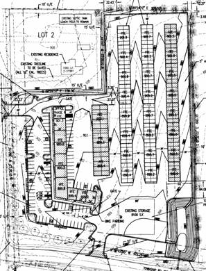
PID-2 (Planned Industrial District); existing mini-storage facility built in southwest corner of PID |
|
Surrounding Zoning:
|
M-1 (Research Industrial) District to the north; developing East Hills Business Park.
PID-2 (Planned Industrial District) to the east; existing LRM development.
PID-2 (Planned Industrial District) to the south; existing Franklin Park development including jail and other warehouse type uses
A (Agricultural) to the west; existing crop land and proposed Fairfield Farms residential, commercial, and industrial development. |
|
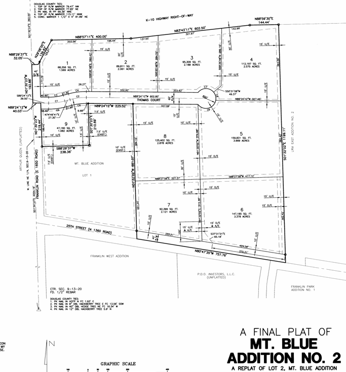
Mt. Blue Addition PID (refer to subdivision plat at end of report) |
Site Summary |
Parking Stall Summary |
|||
|
Lot Total |
10 |
|
|
|
|
|
Lot |
Address |
Building |
Open Space |
Required |
Provided |
|
Lot 1, #2 |
3600 Thomas Ct |
4,000 SF |
39,434 SF |
14 |
17 |
|
Lot 2 , #2 Lot 3, #2 |
3620Thomas Ct 3640 Thomas Ct |
62,100 SF (200 SF office) |
74,811 SF |
1 per 1000 SF or 1 per 1.5 emp. |
12 |
|
Lot 4, #2 |
3660 Thomas Ct |
10,400 SF |
60,021 SF |
56 |
43 |
|
Lot 5, #2 |
3661 Thomas Ct |
46,551 SF |
68,914 SF |
79 |
92 |
|
Lot 6, #2 |
3660 25th St |
21,600 SF |
57,370 SF |
62 |
68 |
|
Lot 7, #2 |
3640 25th St |
18,807 SF |
41,843 SF |
46 |
46 |
|
Lot 8, #2 |
3641 Thomas Ct |
30,985 SF |
74,981 SF |
74 |
68 |
|
Lot 9, #2 |
3601 Thomas Ct |
0 SF |
47,161 SF |
0 |
0 |
|
Lot 1 #1 |
2400 Franklin Rd |
44,172 SF |
57,063 SF |
47 |
76 |
|
Sub Total Total PID |
937,655 27.02 gross acres 25.76 Net acres |
194,443 SF 238,615 SF |
464,535 SF 521,598 SF |
334 371 |
346 422 |
Development History: Mt. Blue Addition PID
The subject property is part of a 40 acre annexation and rezoning request approved in 1994. Subdivision approval occurred in two phases. Mt. Blue Addition, which included only 7.4 acres in the southwest corner of the district, was approved in the fall of 1999. A second plat was approved in 2000 for 23 acres (which included a portion of the original 7 acres). The eastern portion of the district became know as the LRM PID. The Mt. Blue PID was initiated with a Preliminary Development Plan in 1997 for the southeastern 7.4 acres. It was approved for mini-storage and office retail development in two phases. There is no digital image of the Preliminary Development Plan.
A Final Development Plan was approved in April 1997 but was not executed and was ultimately revised in March of 1999. Access to this lot is provided from both Franklin Road and E. 25th Street. Development of this parcel has occurred in phases and has been revised administratively. This lot does not include any interior connections to any other lots within the PID.
A revised Preliminary Development Plan was executed in November 1999 for the “Mt. Blue PID” remaining acreage which was then platted as Mt. Blue Addition No. 2 excluding the developed lot in the southwest corner of the district. The 1999 revised Preliminary Development Plan included individual buildings and parking areas for each lot within the district.
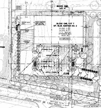
A Final Development Plan was approved in December 2000 for Lot 7, Block 1 of Mt. Blue Addition No. 2. This lot is located immediately east of the existing mini-storage building and fronts onto E. 25th Street. The development was approved, but never constructed. Plan approval expired in June 2001.
|
Existing Mini-Storage Development
|
Expired FDP for warehouse type use |
|
|
|
STAFF ANALYSIS
The property is generally located on the south side of E. 23rd Street (K-10 Highway) and on the east side of Franklin Road. Lot 1, Mt. Blue Addition is a developed property within the Planned Industrial Development. A local street provides access to interior lots as well as E. 25th Street on the south side. The primary purpose of the revised Preliminary Development Plan is to address a proposed change of use for Lots 2 and 3 of Mt. Blue Addition No. 2 to be combined and developed as a single entity. The proposed Revised Preliminary Development Plan for Mt. Blue PID has been evaluated based upon the following suggested findings of fact and conclusions outlined in Section 20-1010.1 of the Zoning Ordinance for the City of Lawrence.
1) In what respects the plan is or is not in general conformity with the provisions of the Comprehensive Plan of the City.
Staff Finding - The property has been zoned for planned industrial development for some time. The proposed change does not modify the underlying land use for the development. The proposed revision is related to a change in the building type and parking arrangement for the development. Restricted land uses are identified in the general notes on the face of the development plan.
2) In what respects the plan is or is not consistent with the Statement of Objectives of Planned Unit Development. [The statement of objectives of planned unit developments is found in Section 20-1002 of the Zoning Ordinance]
Staff Finding –The subject property abuts the E. 23rd Street (K-10 Highway) corridor and must address both extraordinary setback and screening requirements as part of the development consideration. The PID does not include any residential elements. The developed portion includes space for office and commercial retail uses as part of the overall development. Existing infrastructure is in place to serve the property including sanitary sewer, water and streets. Future improvements have been identified for this area and are discussed later in this report. There are no unique or natural features that have been previously identified within this development.
3) The nature and extent of the common open space in the Planned Unit Development, the reliability of the proposals for maintenance and conservation of the common open space, and the adequacy or inadequacy of the amount and function of the common open space in terms of the densities and dwelling types proposed in the plan.
Staff Finding – The development plan exceeds the minimum required open space (42% for Lots 1-9 Mt. Blue Addition No. 2 and 25% for Lot 1, Mt. Blue Addition No. 1. No use of Lot 9 has been shown other than open space. Development of this lot requires revisions in the future and will alter the overall open space for the development. Common areas are not generally found in industrial or commercial areas unless there is a related residential element. Open space is maintained by individual lot ownership within the development.
4) Whether the plan does or does not make adequate provisions for public services, provide adequate control over vehicular traffic, and further the amenities of light and air, recreation and visual enjoyment.
Staff Finding – The public facilities are developed (streets, sanitary sewer and water) for this subdivision. Access is accommodated via an internal local street.
5) Whether the plan will or will not have a substantial adverse effect on adjacent property and the development or conservation of the neighborhood area.
Staff Finding – “Neighborhood area” refers to residential type uses which do not exist in the immediately surrounding area. The property is bounded on the north by E. 23rd Street (K-10 Highway) and by industrial uses to the east and south. The area to the west is undeveloped, and the area west of that parcel has been requested for residential uses. Much of the immediately surrounding area is developed with non residential uses. No adverse effects are anticipated on adjacent properties.
6) In what respects the plan is or is not in conformance with the development standards and criteria of this article. [The general standards are found in Section 20-1006 and Preliminary Development Plan requirements are listed in Section 20-1010]
Staff Finding - The proposed Preliminary Development Plan complies with the applicable requirements of the Zoning Ordinance with the exception that the required parking is misstated. Staff recommends the development plan be revised to correct the required parking summary.
7) In what respects the plan is or is not in compliance with the requirements for application for tentative approval of the Planned Unit Development. [This finding refers to Section 20-1005 of the Zoning Ordinance.]
Staff Finding –The subject property is currently zoned PID and has had development plan approval since 1997. The revision to the interior development concept of building arrangement for Lots 2 and 3, Mt. Blue Addition No. 2 require the revision of the development plan. New information is available regarding future street improvements in the area that are discussed later in the report.
8) The sufficiency of the terms and conditions proposed to protect the interest of the public and the residents of the Planned Unit Development in the case of a plan that proposes development over a period of years.
Staff Finding - The plan indicates that development of the remaining lots will occur in stages and is scheduled to be completed in the spring of 2008. There is no residential element within the Planned Industrial Development that will be affected by any phase of the project.
9) Stormwater detention calculations and storage of excess stormwater drainage as per City Policy.
Staff Finding – The proposed development has been reviewed by the City Stormwater Engineer recommends two conditions be added to the approval to address the provision of easement labels and the need for permitting prior to development.
Staff Review
The PID is located on the southeast corner of E. 23rd Street (K-10 Highway) and Franklin Road. The PID is a total of approximately 27 acres. The property was zoned in 1994. A Preliminary Development Plan (for 12 acres) was approved in 1997 for a mini storage facility on the southwest 5 acres fronting along E. 25th Street and Franklin Road. Uses for the remaining acreage were not defined at that time.
Rights-of-way
The subject property is served with abutting streets; Franklin Road along the west side is an arterial street, Thomas Court is a local street, and E. 25th Street located along the south side of the PID is a collector street. New streets do not need to be constructed to serve this development at this time. As an arterial street, Franklin Road is required to provide a minimum of 100’ of right-of-way. Currently only 80’ of right-of-way exist today. Specific intersection improvements may exceed that requirement.
The subject property is located within the K-10 Corridor Study area. Several future street improvements have been recommended as part of the study including an interchange at Franklin Road and E. 23rd Street (K-10 Highway). The location of the intersection of Thomas Court with Franklin Road is too close to the intersection with E. 23rd Street and will need to be cul-de-saced in the future with alternative access to E. 25th Street provided. Staff recommends the development plan be revised to provide a minimum 30’ public access easement between the east end of Thomas Court and E. 25th Street and to show the location of a cul-de-sac at the western end of Thomas Court. This recommendation requires the development plan to be revised in terms of the parking lot layouts to provide shared north/south access. Physical improvements of the cul-de-sac would not be required at this time and would be included in interchange improvements in the future. Additionally, the north/south access would not be required to be constructed at this time.
Additional right-of-way requirements will be addressed as development occurs within the PID. Property owners should expect additional right-of-way dedications through the final platting and final development plan process as well as public improvement projects that occur in this area.
Use Restrictions
As part of the zoning ordinance both uses and design restrictions were applied to this development. Specific restrictions address building and parking setbacks and screening. Blank wall are prohibited from facing the highway (K-10) or must be fully screened. This element will continue to be evaluated as the property continues through the development process.
The specific tenant of Lot 2 and 3 is described as a professional moving and storage company. The applicant has indicated that the proposed use is not a mini-warehouse facility as defined in Section 20-2003.12(5). The distinction being that individual units are available for rent to tenants for the “purpose of storing and removing personal and or business property.” Such use would be subject to design standards found in Section 20-1456. The proposed Preliminary Development Plan complies with the additional use restrictions set out in Section 20-1456(d). The applicable parking group for the moving storage use is 17 which requires one space per 1000 square feet or one space per 1.5 employees whichever is greater. The development plan should be revised to correct the parking note with the applicable parking citation.
Stormwater
As noted the proposed development has been approved by the City Stormwater Engineer with a recommendation to address labels and the provision of a stormwater pollution prevention plan. These comments are reflected as part of the conditions of approval.