|
PLANNING COMMISSION REPORT SUMMARY Regular Agenda -Public Hearing Item
|
ITEM NO 6: FINAL PLAT FOR MT. BLUE ADDITION NO. 3; SOUTH OF K-10 HIGHWAY & EAST OF FRANKLIN ROAD (SLD)
SUMMARY
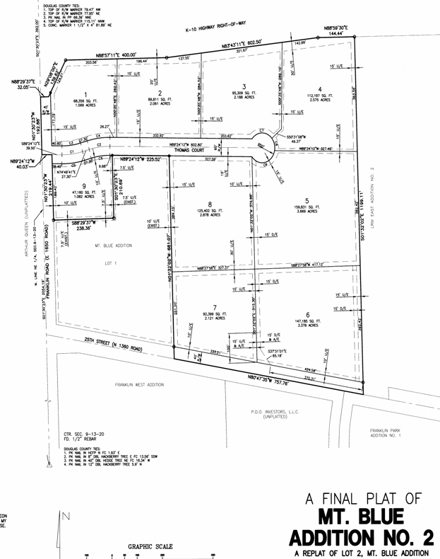
PF-08-32-05: Final Plat for Mt. Blue Addition No. 3, a Replat of Lot 2 and 3, Mt. Blue Addition No. 2. This proposed Planned Industrial Development contains approximately 4.249 acres. The property is generally described as being located south of K-10 Highway and east of Franklin Road. Submitted by Landplan Engineering, P.A., for Mt. Blue, L.C., property owner of record.
|
Recommendation: Staff recommends approval of the Final Plat of Mt. Blue Addition No. 3 and forwarding it to the City Commission for acceptance of easements and rights-of-way subject to the following conditions:
|
|
Reason for Request: |
Combination of lots for proposed moving and storage development within PID |
|
|
KEY POINT · Lot to be combined and remove interior utility easements. |
||
|
FACTORS TO CONSIDER · Compliance with Subdivision Regulations.
|
||
|
ASSOCIATED CASES/OTHER ACTION REQUIRED · A-2-2-94 (annexation of 40 acres). · Z-02-05-94 A to PID-2 (Planned Industrial District) approved with restrictions including use. · PDP-07-06-05 approved by city commission on 9/13/05. · Final Development Plan required for mini-warehouse development.
|
||
|
PUBLIC COMMENT RECEIVED PRIOR TO PRINTING · No comments received
|
||
|
General information |
|
|
Current Zoning and Land Use: |
PID-2 (Planned Industrial District); existing mini-storage facility built in southwest corner of PID |
|
|
Surrounding Zoning:
|
M-1 (Research Industrial) District to the north; developing East Hills Business Park.
PID-2 (Planned Industrial District) to the east; existing LRM development.
PID-2 (Planned Industrial District) to the south; existing Franklin Park development including jail and other warehouse type uses
A (Agricultural) to the west; existing crop land and proposed Fairfield Farms residential, commercial, and industrial development. |
|
Site Summary |
|
|
Number of Lots: |
1 |
|
Gross Area: |
4.249 acres |
|
Rights-of-way: |
No new right-of-way proposed |
STAFF REVIEW
The property is generally located east of Franklin Road and abuts E. 23rd Street on the north side of the lot. Access to the property is provided via Thomas Court along the south property line. The proposed request will result in a replat that combines two lots into a single large lot for development purposes as shown on the approved Preliminary Development Plan for the Mt. Blue PID.
Streets and Access
The subject property is bounded on the north by E. 23rd street. Direct access to this arterial street is prohibited.
Utilities and Infrastructure
one issue is the provision of necessary drainage easements. It was noted during discussion with the City Commission, as part of the zoning (land use) application, that detailed drainage plans would be required as part of the development plan review process for the multi-family development. Drainage easements have been provided as an initial step in that process. Existing infrastructure has been constructed including a local street for access (Thomas Court) and sanitary sewer (located along the north property line). Water may need to be extended and will require appropriate public improvement plans.
Another issue is a requirement of the subdivision regulations that documentation be submitted by the applicant to demonstrate a proposed development takes into consideration the City’s long-range plans, studies, reports, and similar documents for water and wastewater services. All subdivision plats are subject to this review regarding the ability to accommodate sanitary sewer service. “Failure to provide this downstream sanitary sewer analysis as required per section 21-706 (d) of the Subdivision Regulations is sufficient to warrant a denial of a proposed plan.” Staff recommends, as a condition of approval, that this documentation be provided and approved by the City’s Utility Department prior to consideration of the Final Plat by the City Commission for dedication of easements and rights-of-way.
Lot Orientation
The subject property is a single lot that is part of an overall industrial development. Access is accommodated via a local street. The Preliminary Development Plan included discussions related to future road network improvements that will affect this area in the future. The orientation of the lot will not be altered in that the circulation will remain “internal” to the development. Future improvements may affect the lot size depending on the design of the intersection of Franklin Road with E. 23rd Street (K-10 Highway).
SUMMARY
The proposed Final Plat as conditioned is in conformance with subdivision regulations. This development will not include any residential elements as per the approved Preliminary Development Plan. As noted, additional documentation is required to complete various development steps for this property including a downstream sanitary sewer analysis per the approval of the City Utility Department and submission and approval of a Final Development Plan for the development of the lot.
Existing Plan configuration.
|
|