|
PLANNING COMMISSION REPORT Regular Agenda – Public Hearing Item |
PC Staff Report
11/14/05
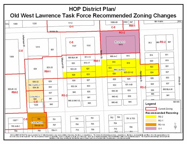
ITEM NO. 12: RM-1 to RO-1; .34 ACRE; NORTH OF W. 7TH STREET (ML)
Z-09-55-05: A request to rezone a tract of land approximately 0.35 acre from RM-1 (Multiple-Family Residence District) to RO-1 (Residence-Office District). The property is generally described as being located north of W. 7th Street and east of Arkansas [630-32 Arkansas and 634-36 Arkansas]. Initiated by the City Commission on September 27, 2005 based on recommendations in the HOP District Plan.
|
STAFF RECOMMENDATION: Staff recommends approval of rezoning approximately one-third acre from the RM-1 District to the RO-1 District and forwarding it to the City Commission with a recommendation for approval based on the findings of fact found in the body of the staff report. |
|
|
Reasons for Request: |
To follow the recommendations of the HOP District Plan to zone property to the current use based on the neighborhood association task force study and recommendation. |
|
KEY POINTS
|
|
GOLDEN FACTORS TO CONSIDER CHARACTER OF THE AREA
CONFORMANCE WITH HORIZON 2020
|
|
ASSOCIATED CASES/OTHER ACTION REQUIRED · Z-09-53-05: C-5 to RO-1A; .53 acres; the corner of W. 7th and Arkansas Streets, 700 and 704-704 ½ Arkansas Street · Z-09-54-05: C-5 to RO-1; .34 acres; north of W. 7th Street, 640 Arkansas Street · Z-09-56-05: RO-2 to O-1; 1.52 acres; south of W. 6th Street, 1015 W. 6th Street · Z-09-57-05: RM-1 to RS-2; 2.11 acres; south of W. 6th Street between Missouri and Illinois Streets
|
|
PUBLIC COMMENT RECEIVED PRIOR TO PRINTING
|
|
GENERAL INFORMATION |
|
|
Current Zoning and Land Use: |
C-5 District; duplexes
|
|
Surrounding Zoning and Land Use:
|
RM-1 (Multiple-Family Residential) District to the north; mobile home park
RS-2 (Single-Family Residential) District to the east; single-family homes.
RM-2 (Multiple-Family Residential) District to the west; apartments
C-5 District to the south; 8-plex
|
I. ZONING AND LAND USES OF SURROUNDING PROPERTIES
The property directly to the north of the subject property is zone RM-1 District and is developed with a mobile home park on the property. The properties to the east are zoned RS-2 District and have single-family homes on the properties. The property directly to the south of the subject property is zoned C-5 District and is developed with an 8-plex. The property to the west is zoned RM-2 District and is developed with a 40 apartments.
Staff Finding – The request is to rezone approximately .35 acres from the RM-1 District to the RO-1 District. The subject properties currently each have a duplex. The areas surrounding the subject properties are zoned C-5 District, RM-1 District, RS-2 District, and RM-2 District. As part of the HOP District Plan recommendations, the neighborhoods were to study the relation of the land use and the zoning of the properties identified in the plan that are included in their neighborhood association and located within the study area of the HOP District Plan. The plan recommended that zoning buffers between uses be utilized, where appropriate.
II. CHARACTER OF THE AREA
Staff Finding – The area is characterized by a variety of densities of residential uses and neighborhood commercial uses. The parcels directly surrounding the subject property are zoned for commercial and residential uses. The subject property is located within the Lawrence city limits.
III. SUITABILITY OF SUBJECT PROPERTY FOR THE USES TO WHICH IT HAS BEEN RESTRICTED
The subject property is currently zoned for multiple-family residential use. According to the City’s Zoning Ordinance, the RM-1 District is “…designed to provide areas for medium and high population density.” The minimum lot size for the RM-1 District is 7,000 square feet and requires a minimum of 3,500 square feet per dwelling unit (12 units per acre) for residential development.
The request is to rezone the subject property to the RO-1 District, which requires a minimum lot area of 6,000 square feet and the RO-1 zone requires 1,000 square feet per dwelling unit (43 units per acre) for residential development. The general purpose of the residence-office district is “…to primarily provide mixed use areas for professional offices, medical and dental clinics and similar types of uses that are compatible with and can be located adjacent to or in combination with single, duplex, or multiple-family residential uses without undue harmful effects to the residential uses.”
Staff Finding –The proposed zoning allows the current use and would allow the properties to redevelop with office and residential uses. The property will gain allowed uses. The majority of the surrounding property is residential.
IV. LENGTH OF TIME SUBJECT PROPERTY HAS REMAINED VACANT AS ZONED
Staff Finding - The properties have been zoned RM-1 District since the adoption of the 1966 City of Lawrence Zoning Regulations.
V. EXTENT TO WHICH REMOVAL OF RESTRICTIONS WILL DETRIMENTALLY AFFECT NEARBY PROPERTY
Staff Finding – As this property has single-family and multi-family development to the east and west, the rezoning of this area is not anticipated to detrimentally affect the nearby property. The rezoning should enhance the existing neighborhood by creating appropriate transitions between uses. It is important to note that the requested RO-1 District is less restrictive than the current RM-1 District.
VI. RELATIVE GAIN TO THE PUBLIC HEALTH, SAFETY AND WELFARE BY THE DESTRUCTION OF THE VALUE OF THE PETITIONER’S PROPERTY AS COMPARED TO THE HARDSHIP IMPOSED UPON THE INDIVIDUAL LANDOWNERS
Evaluation of this criterion includes weighing the benefits to the public versus the benefit of the owners of the subject property. Benefits are measured based on anticipated impacts of the rezoning request on the public health, safety, and welfare.
Staff Finding –With the rezoning of this property to the RO-1 District, it will allow for transitional properties from a higher density, multi-family residential to lower-density residential. Granting the rezoning request would allow the property owners to redevelop the property in the future as a variety of densities of residential and also some professional office uses. Approval of the rezoning request will protect the public health, safety, and welfare by ensuring that appropriate transitions are used between residential and commercial uses.
VII. CONFORMANCE WITH THE COMPREHENSIVE PLAN
The subject property is located north of W. 7th Street and east of Arkansas Street. Horizon 2020 identifies these properties as medium density residential on the future land use map. The following Horizon 2020 goals and associated policies support the rezoning application:
RESIDENTIAL LAND USE GOALS AND POLICIES
Medium-and Higher-Density Residential Land Use
GOAL 3: Compatible Transition from Medium-and Higher-Density Residential Development to both More Intensive and Less Intensive Land Uses (Page 5-25)
Policy 3.1: Use Appropriate Transitional Methods (Page 5-25)
Policy 3.2: Medium Density Residential Development as Transitional Uses (Page 5-26)
Staff Finding – The rezoning conforms to several Horizon 2020 policies related to medium and higher-density residential uses. This property will act as a buffer between the high density residential and low density residential uses. The process of the HOP District Plan and implementation of the plan has allowed the neighborhood to update the zoning of the area to match the current use. The subject properties’ rezonings will allow for the appropriate transitions in the area between commercial uses and low-density residential. This will help to unite the commercial uses to the existing sites.
STAFF REVIEW
The subject property is located north of W. 7th Street and east of Arkansas Street. As previously stated, land uses surrounding the property include single-family homes, apartments and a mobile home park. The zoning will be consistent with the current use if rezoned to RO-1 District along with allowing additional professional offices to redevelop subject to any additional applicable regulations in the Zoning Ordinance. It is also important to note that the application conforms to several Horizon 2020 policies.
|
|