|
PLANNING COMMISSION REPORT REGULAR AGENDA --NON-PUBLIC HEARING ITEM:
|
PC Staff Report
02/26/07
|
ITEM NO. 5A: UR [PCD-2] TO RM-24; SE QUADRANT OF SOUTH LAWRENCE TRAFFICWAY & SIXTH ST/U.S. HWY 40 (SLD)
Z-01-01-07: A request to rezone a tract of land approximately .91 acres, from UR [PCD-2] (Planned Commercial Development) to RM-24 (Multi-Dwelling Residential). The property is located at the SE Quadrant of South Lawrence Trafficway and Sixth Street (U.S. Hwy 40). Submitted by Landplan Engineering, P.A., for Debbie Liu of Diamond Head Limited Partnership, property owner of record.
|
|
STAFF RECOMMENDATION: Staff recommends approval of .91 acres from UR [PCD-2] to RM24 and forwarding it to the City Commission with a recommendation for approval based on the finding of fact stated in the body of the staff report and subject to the recording of a final plat for the subject property. |
Applicant’s Reason for Request: |
Allows for zoning boundary to follow intended development/platted boundaries. |
|
KEY POINTS · Subject property has previously been platted. · Associated request for Final Plat to establish new property lines concurrent with zoning boundary and proposed right-of-way.
|
|
GOLDEN FACTORS TO CONSIDER
CHARACTER OF THE AREA · Developing Commercial and residential area.
CONFORMANCE WITH THE COMPREHENSIVE PLAN · Proposed change is minor and consistent with recommendations for a planned development approach for the area for future development.
|
|
ASSOCIATED CASES/OTHER ACTION REQUIRED · PP-09-17-02 Preliminary Plat of Diamondhead Planning Commission approved on 10/30/02 · FP-09-27-04 Diamondhead approved by the City Commission 11/09/04 recorded on 11/29/04 · PDP 09-08-05 Diamondhead PCD Planning Commission approval on 1/25/06 City Commission approval 3/28/06 · FDP 02-08-07 Northgate PCD (formerly know as Diamondhead) PROPOSED for March 2007 Planning Commission consideration · PF-01-02-07 Final Plat of Diamondhead 2nd Plat PROPOSED for February 2007 Planning Commission consideration · Z-09-33-02 32.713 acres from A (Agricultural) to PCD-2 (Planned Commercial District). Approved May 4, 2004 · Nodal Plan for 6th Street and South Lawrence Trafficway ·
Z-5-12-98 ·
Z-5-13-98 ·
Z-5-14-98 ·
Z-5-15-98 ·
Z-5-16-98 · Z-09-29-02 A to RS-2; 32.253 acres; Diamond Head, southwest corner of 6th Street & George Williams Way - PC approved unanimously on 10/30/02 Ord. 7777; adopted 12/28/04; published 12/31/04 · Z-09-30-02 A to RM-1; 14.467 acres; Diamondhead, southwest corner of 6th Street & George Williams Way - PC approved on 10/30/02 Ord. 7778 · Z-09-31-02 A to RO-2; 7.013 acres; Diamondhead, southwest corner of 6th Street & George Williams Way - PC approved on 10/30/02 Ord. 7779 · Z-09-32-02 A to RM-2; 12.836 acres; Diamondhead, southwest corner of 6th Street & George Williams Way - PC approved on 10/30/02 Ord. 7780 · Z-09-33-02 A to PCD-2; 32.713 acres; Diamondhead, southwest corner of 6th Street & George Williams Way - PC 10/30/02 cc Approved 5/4/04 subject to conditions of PDP approval and recording of FP.
|
|
PUBLIC COMMENT RECEIVED PRIOR TO PRINTING · None received to date
|
|
GENERAL INFORMATION |
|
|
Current Zoning and Land Use: |
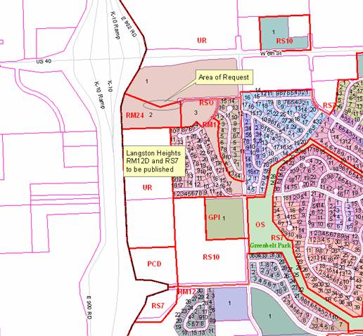
UR [Urban Reserve]; undeveloped ground, currently part of a larger area pending publication of PCD-[Diamondhead]. |
|
Surrounding Zoning and Land Use: |
RM24 [Multi-Dwelling] District to the south (subject property to be merged with this area; undeveloped
RSO [Single-Dwelling Residential-Office] to the east; undeveloped property
UR [Urban Reserve]; undeveloped ground to the north and west; currently part of a larger area pending publication of PCD-[Diamondhead]. |
STAFF REVIEW
I. CONFORMANCE WITH THE COMPREHENSIVE PLAN
The proposed rezoning does not add new commercial land area. The proposed request represents a modification in the boundary lines between districts consistent with development plans for the area and based on the orderly extension of a public street (Ken Ridge Drive extended) to serve the surrounding area.
The proposed reduction in the commercial area does not create a non-conforming situation or commercial lot. Under the original approval, Commercial Planned Unit Developments were required to include a minimum of 2 acres. The original approval established at total of 32.713 acres of commercial area included in the Diamondhead development. The Land Development Code, likewise, requires a minimum area of five acres for Planned Developments. The proposed change reduces the total area, but still exceeds these minimum standards.
The commercial development will continue to be developed consistent with recommendations related to “nodal development”.
The subject property will be incorporated into the multi-dwelling district. The boundary of the area and total acreage will be technically expanded, but the density of development is unlikely to be altered (no development proposals for that area have been submitted) because this area would be used for the public street extension of Ken Ridge Drive.
Staff Finding – The proposed change is in conformance with Horizon 2020.
II. ZONING AND USE OF NEARBY PROPERTY, INCLUDING ANY OVERLAY ZONING
The subject property is a part of an existing PCD area that has not yet been published. The approval for rezoning was subject to the approval of a Preliminary Development Plan for the property. A Final Development Plan has been submitted for the Planning Commission consideration for March 2007.
The surrounding area includes RM24 (proposed zoning district) and RSO to the east. These properties are undeveloped at this time. They are part of the original Diamondhead plat that subdivided the original 122 acres into areas for multi-family, single-family detached, mixed residential-office and commercial areas as a comprehensive development.
Staff Finding – The subject property lies at the boundary between the remaining PCD-2 district and the majority of the RM24 area for which it will be incorporated if approved. The immediately adjacent properties are undeveloped. The single-family detached lots are currently being developed located to the southeast of the subject property.
III. CHARACTER OF NEIGHBORHOOD
Staff Finding – The subject property is located within a developing area bounded by W. 6th Street on the north and K-10 Highway on the west. The immediate area is undeveloped. The area along George Williams Way is zoned and platted for attached dwelling units (duplex and triplex) as well as single-family detached housing to the south of the subject property.
IV. PLANS FOR THE AREA OR NEIGHBORHOOD, AS REFELCTED IN ADOPTED AREA AND/OR SECTOR PLNAS INCLUDING THE PROEPRTY OR ADJOINING PROEPRTY
Staff Finding –The subject property is part of an original 122 acre planned development that included multiple land uses with streets connecting the various areas. Since the original approval additional land use approvals to the south of the subject property have been considered (Langston Heights, a residential subdivision including single-dwelling and duplex lots) has been approved and included the extension of Ken Ridge Drive to the west and then south. This street alignment required the amendment to the location of the drainage easement and adjacent lot lines. As part of the original approval a nodal plan was adopted prior to rezoning approval for the 6th Street and K-10 Highway intersection. The proposed request does not alter the intent of land uses for the area. The net effect is a reduction in total area zoned PCD [Diamondhead] and an increase in the boundary of the area zoned for multi-family. The affected area is largely used for street and stormwater purposes.
V. SUITABILITY OF SUBJECT PROPERTY FOR THE USES TO WHICH IT HAS BEEN RESTRICTED UNDER THE EXISTING ZONING REGULATIONS
The original boundary of the zoning district was established prior to the finalization of development plans for the area. Langston Heights Final Plat included RM12D and RS7 south of the subject property that showed the extension of Ken Ridge Drive to the south parallel to K-10 Highway. It was noted at this time that adjustments would be probable for a small area so that the zoning boundary and the amended lot lines would align.
The revised boundaries reflected on the Final Plat of Diamondhead 2nd plat shows the extension of the right-of-way establishing the north right-of-way line as the district boundary. This effectively reduces the total area of the PCD by less than one acre and includes it into the existing multi-family district.
Staff Finding – The proposed rezoning is consistent with the practice of establishing zoning and lot lines concurrently. If left unchanged the PCD-2 district boundary would extend in an odd manner into the right-of-way of the proposed street. Approval of the request does not alter the overall suitability for the development pattern previously established for the area.
VI. LENGTH OF TIME SUBJECT PROPERTY HAS REMAINED VACANT AS ZONED
Staff Finding – The PCD-2 was approved in 2004 subject to conditions relating to the finalization of plans for the commercial portion of the entire 122 acres and the recording of a final plat. The development plan is in process and will be considered at a later date by the Planning Commission. The present zoning of UR is currently in place as a result of the adoption of the Land Development Code effective July 1, 2006.
VII. EXTENT TO WHICH APPROVIING THE REZONING WILL DETRIMENTALLY AFFECT NEARBY PROPERTIES
Staff Finding – The proposed rezoning is a technical downgrade of land-use intensity from commercial to multi-family residential. Both immediately adjacent properties are undeveloped and in the planning stages. There is no anticipated detrimental impact or affect on adjacent properties as a result of approval of the proposed zoning change.
VIII. THE GAIN, IF ANY, TO THE PUBLIC HEALTH, SAFETY AND WELFARE DUE TO DENIAL OF THE APPLICATION, AS COMPARED TO THE HARDSHIP IMPOSED UPON THE LANDOWNER, IF ANY, AS A RESULT O0F DENIAL OF THE APPLICATION;
Staff Finding –Approval of the request will not impact the public health and safety either positively or negatively. Approval of the request will allow for better and more efficient mapping and calculation of areas and densities for the associated properties as the boundaries of the two zoning districts are adjusted.
|
General Area:
|