(Published in the Lawrence
Journal-World on February , 2014)
RESOLUTION NO. 7059
A RESOLUTION SETTING FORTH FINDINGS
AND DETERMINATIONS OF THE GOVERNING
BODY OF THE CITY OF LAWRENCE,
KANSAS ON THE ADVISABILITY OF AND AUTHORIZING THE CONSTRUCTION OF CERTAIN IMPROVEMENTS WITHIN YANKEE TANK ESTATES PURSUANT
TO K.S.A. 12-6a01 et seq.
WHEREAS, a petition was filed with the City Clerk for the City of Lawrence, Kansas (the “City”) on February , 2014, proposing
certain improvements pursuant to K.S.A. 12-6a01 et seq. (the “Petition”); and
WHEREAS, the Petition sets forth: (a) the general nature of the proposed improvements; (b) the estimated or probable cost of the proposed improvements; (c) the extent of the proposed improvement district to be assessed for the cost of the proposed improvements; (d) the proposed method of assessment;
(e) the proposed apportionment of the cost between the improvement district and the City at large; and (f) a request that such improvements be made without notice and hearing as required by K.S.A. 12-6a04(a); and
WHEREAS, all the owners of record of property
located within the proposed improvement district have signed the Petition; and
WHEREAS, no signatures have been withdrawn from the petition before the Governing Body began consideration of the Petition; and
WHEREAS, K.S.A. 12-6a04 provides that the Governing Body may authorize and order public improvements without notice and hearing after a sufficient petition has been filed.
NOW THEREFORE, BE IS RESOLVED BY THE GOVERNING BODY OF THE CITY OF LAWRENCE, KANSAS, AS FOLLOWS:
Section 1. The Governing Body hereby finds that the Petition is sufficient, and further finds and determines that it is necessary and advisable to make the following improvements:
(a)
The nature
of the improvements are as follows:
THE CONSTRUCTION OF ATCHISON
AVENUE FROM W. 31ST STREET TO W. 32ND STREET, THE CONSTRUCTION OF 32ND STREET FROM E. 1200 ROAD (KASOLD DRIVE) TO ATCHISON
AVENUE, THE CONSTRUCTION OF E.
1200 ROAD (KASOLD DRIVE) FROM W. 32ND STREET TO 31ST STREET, AND A LEFT TURN LANE ON 31ST STREET TO ATCHISON AVENUE, ALL INCLUDING PAVEMENT, CURB AND GUTTER, SUBGRADE STABLIZATION, STORM SEWER AND DITCH GRADING, SIDEWALKS ON BOTH SIDES; THE CONSTRUCTION OF WATERLINE ALONG 32ND STREET FROM KASOLD DRIVE TO ATCHISON AVENUE, AND ALONG ATCHISON AVENUE FROM 31ST STREET TO 32ND STREET; AND OTHER NECESSARY AND APPROPRIATE IMPROVEMENTS
(the “Improvements”).
(b)
The estimated cost of the Improvements
is:
$689,200.00 (to be increased at the pro-rata
rate of 1 percent
per month from and after the adoption
date of the resolution
authorizing the improvements), plus costs of
issuance and plus costs
of interest on any temporary financing.
(c)
The boundaries of the improvement district to
be assessed
are:
A TRACT OF LAND IN THE NORTHWEST
QUARTER OF SECTION 14, TOWNSHIP
13 SOUTH, RANGE 19 EAST OF THE SIXTH PRINCIPAL
MERIDIAN, IN THE CITY OF LAWRENCE, DOUGLAS COUNTY, KANSAS, NOW
DESCRIBED AS FOLLOWS:
BEGINNING AT THE NORTHWEST CORNER OF SAID QUARTER SECTION; THENCE NORTH 88° 10' 16” EAST ALONG THE NORTH LINE OF SAID QUARTER
SECTION, 902.78
FEET; THENCE SOUTH 01° 45' 52” EAST, 417.31
FEET; THENCE NORTH 88° 09' 59” EAST, 422.09 FEET TO A POINT ON THE EAST LINE OF THE WEST HALF OF SAID QUARTER
SECTION; THENCE SOUTH 01° 49'
35” EAST ALONG SAID EAST LINE , 905.27 FEET; THENCE SOUTH 88° 06' 55” WEST, 1136.40 FEET TO A POINT ON THE RIGHT-OF-WAY LINE OF KANSAS STATE HIGHWAY 10; THENCE
NORTH 11° 06' 57” WEST ALONG SAID RIGHT-OF-WAY LINE , 85.83 FEET; THENCE SOUTH 88° 12' 46” WEST ALONG SAID RIGHT-OF-WAY LINE ,
175.00 FEET TO A POINT ON THE WEST LINE OF SAID QUARTER SECTION; THENCE NORTH 01° 47' 14” WEST ALONG SAID WEST LINE, 578.82
FEET; THENCE NORTH 88° 12' 46” EAST, 97.00 FEET; THENCE NORTH 01° 47' 14” WEST,
40.00 FEET; THENCE SOUTH 88° 12' 46” WEST, 97.00 FEET TO A POINT ON THE WEST LINE OF SAID QUARTER
SECTION; THENCE NORTH 01° 47'
14” WEST ALONG SAID WEST LINE, 620.00 FEET TO THE POINT OF BEGINNING. THE ABOVE
CONTAINS 35.760 ACRES,
MORE OR LESS.
EXCEPT THAT THE IMPROVEMENT DISTRICT SHALL EXCLUDE THAT PORTION OF
THE LAND DESCRIBED AS “TRACT A”
ON
THE ATTACHED FINAL PLAT.
(d)
The method
of assessment shall be:
All property in the Improvement District located
on the west side of Atchison Street and north of 32nd Street (Proposed) shall be assessed 50% of the costs of the Improvements, and all lots and tracts located
on the east side of Atchison Street (Proposed) and on the south side of 32nd Street (Proposed) shall be assessed 50% of the costs of the Improvements. The costs shall thereafter be spread
against such
property equally per square foot.
(e)
The apportionment of cost between
the improvement district
and the city at large
is:
One hundred percent (100%) of the costs of the Improvements shall be paid by the improvement district and zero percent (0%) of the cost of the Improvements shall be paid
by the
city at large.
Section 2. The Governing Body hereby declares that the Improvements described in this Resolution are necessary, and authorizes them to be made in accordance with the findings set forth in this Resolution, and further authorizes the levying of assessments and the issuance of bonds therefore, all in accordance with K.S.A. 12-6a01 et seq.
Section 3. The City expects to make capital expenditures from and after the date of this Resolution in connection with the Improvements described herein, and intends to reimburse itself for such expenditures with the proceeds of one or more series of general obligation bonds and temporary notes of the City in the maximum principal amount of $689,200.00, to be increased at the pro-rata rate of one percent per month from and after the adoption
date of the resolution authorizing the Improvements, plus costs of issuance,
and plus costs of interest on any temporary financing.
Section 4. The City Clerk shall file a certified copy of this Resolution with the Register
of Deeds of Douglas County,
Kansas.
Section 5. This Resolution shall take effect after its passage and publication once in the official city newspaper.
ADOPTED AND PASSED this day of February, 2014.
 Mayor
Mayor
(SEAL)
 City Clerk
EXHIBIT A – FINAL PLAT TO
BE RECORDED
LEGALDESCRIPTION
ATRACTOFLANDINTHENORTHWESTQUARTEROFSECTION14,TOWNSHIP13SOUTH,RANGE19EASTOFTHESIXTH
PRINCIPALMERIDIAN,INTHECITYOFLAWRENCE,DOUGLASCOUNTY,KANSAS,NOWDESCRIBEDASFOLLOWS:
BEGINNING AT THE NORTHWEST CORNER OF SAID QUARTER SECTION;
THENCE NORTH 88° 10' 16"
EAST ALONG THE NORTH LINE OF SAID QUARTER SECTION,
902.78 FEET; THENCE
SOUTH 01° 45' 52" EAST, 417.31 FEET; THENCE NORTH 88° 09' 59"
EAST, 422.09 FEET TO A POINT ON THE EAST LINE OF THE WEST HALF OF SAID QUARTER
SECTION; THENCE SOUTH 01° 49' 35"
EAST ALONG SAID EAST LINE , 905.27
FEET; THENCE SOUTH
88° 06' 55"
WEST, 1136.40 FEET TO A POINT ON THE
RIGHT-OF-WAY LINE OF KANSAS
STATE HIGHWAY 10; THENCE NORTH 11° 06' 57" WEST ALONG SAID RIGHT-OF-WAY LINE ,
85.83
FEET; THENCE
SOUTH 88° 12' 46" WEST ALONG SAID RIGHT-OF-WAY LINE , 175.00
FEET TO A POINT ON THE WEST LINE OF SAID QUARTER
SECTION; THENCE NORTH 01° 47' 14" WEST ALONG SAID WEST LINE, 578.82 FEET; THENCE NORTH 88° 12'
46" EAST,
97.00 FEET; THENCE
NORTH 01° 47' 14" WEST,
40.00 FEET; THENCE
SOUTH 88° 12' 46" WEST,
97.00 FEET TO A POINT ON THE WEST LINE OF SAID QUARTER SECTION;
THENCE NORTH 01° 47' 14"
WEST ALONG SAID WEST LINE, 620.00 FEETTOTHEPOINTOFBEGINNING.THEABOVECONTAINS35.760ACRES,MOREORLESS.
ENDORSEMENTS
ApprovedbyCityofLawrence Rights-of-WayandEasements
PlanningCommission AcceptedbyCityCommission
DouglasCounty,Kansas Lawrence,Kansas

 ChairpersonDate MayorDate
BryanCulver MichaelDever
 ReviewedInComplianceWith K.S.A.58-2005.
 DEDICATION
BeitknowntoallmenthatI(we),theundersignedowner(s)oftheabovedescribedtractofland,havehad causeforthesametobesurveyedandplattedunderthenameof"YankeeTankEstates"andhavecaused thesametobesubdividedintolotsandstreetsasshownandfullydefinedonthisplat.Allstreets,drives,
roads,etc.shownonthisplatandnotheretoforededicatedtopublicuseareherebysodedicated.An easementisherebygrantedtotheCityofLawrenceandPublicUtilityCompaniestoenterupon,construct
andmaintain"utilityeasement"or"ue","drainageeasement"or"de",and"pedestrianandright-of-way
CityClerkDate DianeM.Trybom
 MichaelD.Kelly,P.L.S.869 DouglasCountySurveyor
easement"or"rw".
 HarveyMurphy,Trustee
TheKansasDistrictoftheWesleyanChurch,Inc.
HarveyMurphy,Trustee
TheKansasDistrictoftheWesleyanChurch,Inc.
ACKNOWLEDGEMENT
StateofKansas CountyofDouglas
Beitrememberedthatonthis dayof ,2014,beforeme,theundersigned,a notarypublic,inandforsaidcountyandstate,cameHarveyMurphy,Trustee,onbehalfofTheKansas
DistrictoftheWesleyanChurch,Inc.whois(are)personallyknowntometobethesameperson(s)who
executedtheforegoinginstrumentofwritinganddulyacknowledgetheexecutionofthesame.
Inwitnesswhereof,Ihavehereuntosetmyhandandaffixedmysealonthedayandyearlastwritten
above.
 NotaryPublicMycommissionexpires
NOTES
1.
BasisforbearingsforthisplatisStatePlaneCoordinates-KansasNorthZone.
2.
StreettreesshallbeprovidedinaccordancewiththeMasterStreetTreePlanfiledwiththeregisterof
deeds.Book ,Page .
3.
AdjacentpropertyownersarerequiredtomaintainalldrainageeasementsnotownedbytheCity.
Structures,fences,andcutfilloperationsareprohibitedwithindrainageeasements.
4.
LotpinningshallbecompletedinaccordancewithArticle8,Section20-811(k).
5.
Aportionofthisplatisencumberedbyadesignated"SpecialFloodHazardArea"(SFHA)perFEMA
MapNumber:20045C0167D,MapRevised:August5,2010.
6.
MinimumElevationsofBuildingOpenings(MEBO's)havebeenspecifiedforlotsadjacenttotheSFHA anddrainageeasements.IfabasementisbuiltonaLotwhereaMEBOhasbeenestablished,the buildingdesignisencouragedtoincorporateasumppump.
7.
AdditionalinformationisprovidedontheassociatedPreliminaryPlat.
8.
"A total of 126 dwelling
units on Blocks 1, 3, 4, and 5 was approved with the rezoning
of the property to the RM12 and RM12FP
Districts (Z-13-00249 and Z-13-00250). Per these rezoning
approvals, the RM12-FPzonedareainTractAisincludedinthedensitycalculationsbasedonthefactthattheopen spaceinTractAwillservetheresidentsofthisdevelopment.AnoteonthePreliminaryPlatspecifies
thatTractAisbeingprovidedasopenspaceforthisdevelopment.Underthismethodofcalculating
density,18unitsarepermittedonLot1,BlockOne,and108duplexunitsarepermittedonthe54
lots on Blocks 3, 4, and 5. This density
calculation is based on circumstances unique to this property
and does not establish a precedent."
9.
Approximately86oftheregulatoryfloodplainfringehasbeenincludedinTractAforprotectionof
theenvironmentallysensitiveland.Thereshallbenogradingorfillinginthefloodplainwithoutan
approvedFloodplainDevelopmentpermit.Therewillbenostructuresorbuildingsallowedinthe floodplaininTractA.Mowing,vegetationremoval,andotherlimitedmaintenanceactivitiesshallbe
allowedinTractA.TractAisbeingprovidedasopenspaceforthisdevelopment.Ahomeowners associationwillbeformedtoprovideformaintenanceoftheTract.
10.
StreettreesalongTractAshallbeinstalledbythepropertyownerwiththedevelopmentofLot1,
BlockTwo.
FILINGRECORD
StateofKansas CountyofDouglas
ThisistocertifythatthisinstrumentwasfiledforrecordintheofficeoftheDouglas CountyRegisterofDeedsonthis dayof ,2014,andisduly recordedat AMPM,inplatbook page .
 RegisterofDeeds KayPesnell
SURVEYOR'SCERTIFICATION
Iherebycertifythattheplattedareashownhereonisthetrueandaccurateresultofa
fieldsurveyperformedundermydirectsupervisioninNovember,2013,andthatthe platisaclosedtraverse.ThissurveyconformstotheKansasMinimumStandardsfor BoundarySurveys.
StevenD.Williams,P.L.S.1391 P.O.Box4444
Lawrence,KS66046 (785)832-2121
ENGINEER'SCERTIFICATION
Iherebycertifythattheinformationandareamapshownhereonaretrueand accuratetothebestofmyknowledge.PlatpreparedJanuary,2014.
JohnDeanGrob ProfessionalEngineer12769 P.O.Box502
Lawrence,KS66044 (785)856-1900
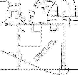
 LOCATIONMAP
|
|
MEBOTABLE
|
|
|
LOTNO.
|
BLOCKNO.
|
MEBO
|
|
12
|
FIVE
|
847.60
|
|
13
|
FIVE
|
847.60
|
|
14
|
FIVE
|
833.00
|
|
15
|
FIVE
|
845.90
|
|
16
|
FIVE
|
845.90
|
|
17
|
FIVE
|
833.00
|
|
18
|
FIVE
|
833.00
|
|
19
|
FIVE
|
833.00
|
|
6
|
THREE
|
845.90
|
|
|
CURVETABLE
CURVE
C1
C2 C3
C4 C5 C6 C7
LENGTH
84.87
121.24
10.60
60.00
60.00
27.02
25.09
RADIUS
70
100
130
130
130
130
70
CHORD
79.77
113.95
10.60
59.47
59.46
26.97
24.95
BEARING S36°33'34"E S36°33'34"E S04°09'40"E
S19°43'13"E S46°09'51"E S65°20'20"E N08°26'26"E
LEGEND
OFFSITEPROPERTYLINE
CENTERLINE
PROPERTYLINE
EASEMENT
SECTIONLINE
C8 C9 C10 C11
C12
35.84
46.59
25.09
35.85
11.59
100
130
70
100
130
35.65
46.34
24.96
35.66
11.59
N08°26'26"E N08°26'26"E S81°33'44"E S81°33'44"E
S73°50'48"E
SCALE1"=1000'
RWE
RWEASEMENT
FEMABOUNDARIES
C13
35.01
130
34.91
S84°06'58"E
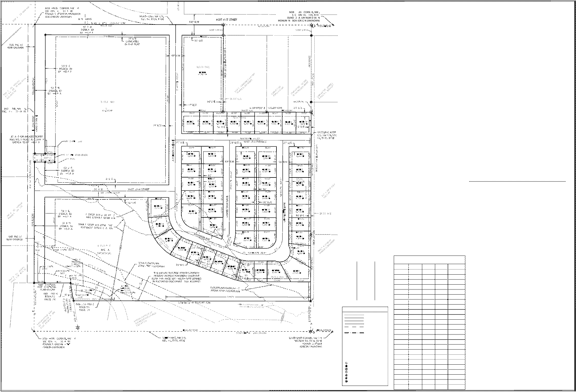

 N SCALE: 1"=80' 0
80'
160'
RW
AE
DE
UE
PEDE
(P)
(D)
(M)
(CM)
RIGHT-OF-WAY
ACCESSEASEMENT
DRAINAGEEASEMENT
UTILITYEASEMENT
PEDESTRIANEASEMENT
PLATTED
DEEDED
MEASURED
CALCULATEDFROMMEASUREMENTS
FOUND:34"REBAR-ORIGINUNKNOWN
FOUND:58"REBAR-ORIGINUNKNOWN
FOUND:1"SQUAREBAR-ORIGINUNKNOWN
FOUND:12"BARWCAP"KANSAS1252" CALCULATEDPOSITION(NOTSET) SET:12"X24"REBARWCAP"APS1391"
SET:MAGNAIL
C14 C15 C16 C17 C18 C19 C20 C21 C22 C23 C24
78.54
62.83
20.59
60.00
47.78
18.95
106.19
106.16
47.71
20.51
61.95
50
80
50
50
50
230
230
230
230
230
230
70.71
61.23
20.45
56.46
45.99
18.94
105.25
105.22
47.62
20.51
61.76
N43°10'16"E N65°40'11"E
S78°32'14"E N55°17'10"E N06°28'11"W S04°08'50"E S19°44'01"E
S46°11'01"E S65°20'58"E S73°50'50"E S84°07'00"E
 afinalplatof
YANKEETANK
ESTATES
ASUBDIVISIONINTHECITYOFLAWRENCE,
DOUGLASCOUNTY,KANSAS
 NW 1,SEC.14-T13S-R19E
PreparedJanuary16,2014